IMAGES TAKEN NEAR TO
Talbot Crescent, LONDON, NW4 4HS
Introduction
This page details the photographs taken nearby to Talbot Crescent, NW4 4HS by members of the Geograph project.
The Geograph project started in 2005 with the aim of publishing, organising and preserving representative images for every square kilometre of Great Britain, Ireland and the Isle of Man.

There are currently over 7.5m images from over14,400 individuals and you can help contribute to the project by visiting https://www.geograph.org.uk
Image Map
Images are licensed for reuse under creativecommons.org/licenses/by-sa/2.0
Notes
- Clicking on the map will re-center to the selected point.
- The higher the marker number, the further away the image location is from the centre of the postcode.
Image Listing (106 Images Found)
Images are licensed for reuse under creativecommons.org/licenses/by-sa/2.0
Image
Details
Distance
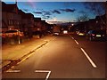
5
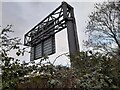
Rear of direction sign on the M1, Hendon
Showing directions off the motorway from J1 at Staples Corner.
Image: © David Howard
Taken: 3 Feb 2022
0.11 miles
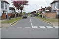
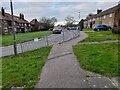
10

Station Road, NW4
The west side, between Edgeworth Avenue and Vaughan Avenue.
Image: © Mike Quinn
Taken: 17 Jan 2012
0.12 miles