IMAGES TAKEN NEAR TO
Vivian Avenue, LONDON, NW4 3EJ
Introduction
This page details the photographs taken nearby to Vivian Avenue, NW4 3EJ by members of the Geograph project.
The Geograph project started in 2005 with the aim of publishing, organising and preserving representative images for every square kilometre of Great Britain, Ireland and the Isle of Man.

There are currently over 7.5m images from over14,400 individuals and you can help contribute to the project by visiting https://www.geograph.org.uk
Image Map
Images are licensed for reuse under creativecommons.org/licenses/by-sa/2.0
Notes
- Clicking on the map will re-center to the selected point.
- The higher the marker number, the further away the image location is from the centre of the postcode.
Image Listing (119 Images Found)
Images are licensed for reuse under creativecommons.org/licenses/by-sa/2.0
Image
Details
Distance
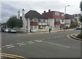
1

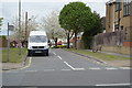
Neeld Crescent at the junction of Vivian Avenue
The Neeld family were one of the original owners of land in the area.
Image: © David Howard
Taken: 9 Aug 2023
0.01 miles
2
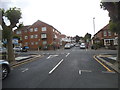
Neeld Crescent at the junction of Vivian Avenue
Image: © David Howard
Taken: 16 Jun 2016
0.03 miles
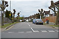
4
Audley Road, Hendon
The blocked off part looking towards Station Road
Image: © David Howard
Taken: 30 Oct 2013
0.04 miles
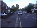
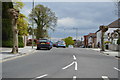
5
Vivian Avenue on the corner of Rundell Crescent
Taken outside Sainsbury's which was why I was here.
Image: © David Howard
Taken: 27 May 2019
0.07 miles
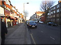
6
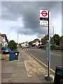
Audley Road Bus Stop
This is Station Road you can see here. Audley Road is off to the right.
Image: © Des Blenkinsopp
Taken: 16 Oct 2014
0.07 miles
9

Sainsbury's Local on the corner of Rundell Crescent, Hendon
Image: © David Howard
Taken: 9 Aug 2023
0.07 miles