IMAGES TAKEN NEAR TO
Allington Road, LONDON, NW4 3DP
Introduction
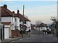
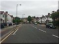
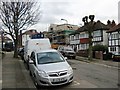
This page details the photographs taken nearby to Allington Road, NW4 3DP by members of the Geograph project.
The Geograph project started in 2005 with the aim of publishing, organising and preserving representative images for every square kilometre of Great Britain, Ireland and the Isle of Man.

There are currently over 7.5m images from over14,400 individuals and you can help contribute to the project by visiting https://www.geograph.org.uk
Image Map (Loading...)


Getting Data...Please wait
Leaflet Map data © OpenStreetMap
Images are licensed for reuse under creativecommons.org/licenses/by-sa/2.0
Notes
- Clicking on the map will re-center to the selected point.
- The higher the marker number, the further away the image location is from the centre of the postcode.
Image Listing (22 Images Found)
Images are licensed for reuse under creativecommons.org/licenses/by-sa/2.0
Image
Details
Distance
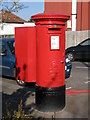
3
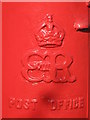
Edward VIII postbox, Elliot Road, NW4 - royal cipher
See Image
Image: © Mike Quinn
Taken: 10 Apr 2008
0.12 miles
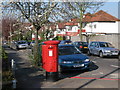
4
Edward VIII postbox, Elliot Road, NW4
The location of this postbox is shown in Image
Image: © Mike Quinn
Taken: 10 Apr 2008
0.12 miles
8
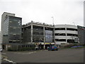
Multi storey car park at Brent Cross Shopping Centre
Image: © Richard Rogerson
Taken: 26 Mar 2009
0.16 miles