IMAGES TAKEN NEAR TO
Shirehall Gardens, LONDON, NW4 2QT
Introduction
This page details the photographs taken nearby to Shirehall Gardens, NW4 2QT by members of the Geograph project.
The Geograph project started in 2005 with the aim of publishing, organising and preserving representative images for every square kilometre of Great Britain, Ireland and the Isle of Man.

There are currently over 7.5m images from over14,400 individuals and you can help contribute to the project by visiting https://www.geograph.org.uk
Image Map
Images are licensed for reuse under creativecommons.org/licenses/by-sa/2.0
Notes
- Clicking on the map will re-center to the selected point.
- The higher the marker number, the further away the image location is from the centre of the postcode.
Image Listing (169 Images Found)
Images are licensed for reuse under creativecommons.org/licenses/by-sa/2.0
Image
Details
Distance
1
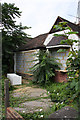
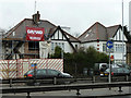
Abandoned Bungalow
One of a number of properties along this stretch of the North Circular Road to have been left to its fate. The pressure of the traffic just a few yards away, 24 hours a day, seems to be gradually driving people away.
Image: © Martin Addison
Taken: 26 Jul 2008
0.07 miles
2
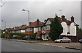
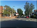
Shirehall Lane
Semi-detached housing in a mix of styles along the south-eastern side of the road by the junction with Shirehall Gardens.
Image: © Martin Addison
Taken: 14 Dec 2008
0.09 miles
3
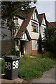
Abandoned House
An empty semi-detached property on the North Circular Road. On almost any other street in the area these would be desirable properties. A community that came into being in the 1950's is gradually dying under the weight of today's traffic.
Image: © Martin Addison
Taken: 26 Jul 2008
0.10 miles
4

Bungalows beside the A406
The section of the North Circular Road between Brent Street and Shirehall Park consists mainly of bungalows, though these are the only ones that are set back from the road. A number of the ones closer to Brent Cross have fallen into disrepair and been abandoned.
Image: © Martin Addison
Taken: 26 Jul 2008
0.10 miles
5
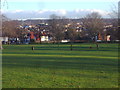
View from Hendon Park
Looking towards Golders Green
Image: © David Howard
Taken: 26 Jan 2012
0.11 miles
6
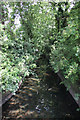
River Brent
Viewed from Shirehall Park, looking towards Brent Street.
Image: © Martin Addison
Taken: 27 Jul 2008
0.11 miles
7
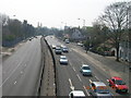
North Circular Road, London NW11
Looking south from the footbridge at its crossroads with Golders Green Road NW11 and Brent Street NW4
Image: © Robin Sones
Taken: 14 Apr 2007
0.11 miles
8
Houses on North Circular Road
Opening directly on to the busy main road.
Image: © Robin Webster
Taken: 26 Feb 2011
0.12 miles
9
Shirehall Park at the junction of Shirehall Lane
Image: © David Howard
Taken: 7 Sep 2021
0.12 miles
10
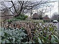
Hedge by Shirehall Lane, Hendon
Along the boundary of Hendon Park
Image: © David Howard
Taken: 7 Jan 2022
0.12 miles