IMAGES TAKEN NEAR TO
Shirehall Park, LONDON, NW4 2QL
Introduction
This page details the photographs taken nearby to Shirehall Park, NW4 2QL by members of the Geograph project.
The Geograph project started in 2005 with the aim of publishing, organising and preserving representative images for every square kilometre of Great Britain, Ireland and the Isle of Man.

There are currently over 7.5m images from over14,400 individuals and you can help contribute to the project by visiting https://www.geograph.org.uk
Image Map
Images are licensed for reuse under creativecommons.org/licenses/by-sa/2.0
Notes
- Clicking on the map will re-center to the selected point.
- The higher the marker number, the further away the image location is from the centre of the postcode.
Image Listing (123 Images Found)
Images are licensed for reuse under creativecommons.org/licenses/by-sa/2.0
Image
Details
Distance
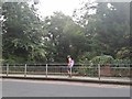
1
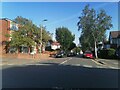
Shirehall Park at the junction of Shirehall Lane
Image: © David Howard
Taken: 7 Sep 2021
0.05 miles
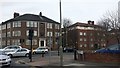
3
Shirehall Lane at the junction of Brent Street
Image: © David Howard
Taken: 7 Jan 2022
0.05 miles
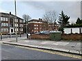
5
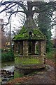
Gazebo, Brent Park
One of a pair of crumbling gazebos on the site of the former Brent Bridge Hotel.
Image: © Jim Osley
Taken: 10 Jan 2011
0.06 miles
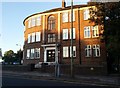
6
Brent Street at the end of Shirehall Lane
Image: © David Howard
Taken: 1 Apr 2016
0.07 miles
7
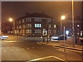
Shirehall Park at the junction of Brent Street
Image: © David Howard
Taken: 22 Dec 2017
0.07 miles
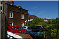
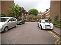
10
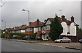
Shirehall Lane
Semi-detached housing in a mix of styles along the south-eastern side of the road by the junction with Shirehall Gardens.
Image: © Martin Addison
Taken: 14 Dec 2008
0.08 miles