IMAGES TAKEN NEAR TO
Englands Lane, LONDON, NW3 4YD
Introduction
This page details the photographs taken nearby to Englands Lane, NW3 4YD by members of the Geograph project.
The Geograph project started in 2005 with the aim of publishing, organising and preserving representative images for every square kilometre of Great Britain, Ireland and the Isle of Man.

There are currently over 7.5m images from over14,400 individuals and you can help contribute to the project by visiting https://www.geograph.org.uk
Image Map
Images are licensed for reuse under creativecommons.org/licenses/by-sa/2.0
Notes
- Clicking on the map will re-center to the selected point.
- The higher the marker number, the further away the image location is from the centre of the postcode.
Image Listing (263 Images Found)
Images are licensed for reuse under creativecommons.org/licenses/by-sa/2.0
Image
Details
Distance
3
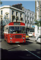
C11 to Willesden Green
BS5 turns into Primrose Hill Road from Englands Lane. These very short Bristol LH buses replaced Ford Transits on the route in 1975. The pub behind the bus is the Washington. Just visible on the corner, to the right of the bus, is a BT tent where some work on the cables is being carried out.
Image: © Martin Addison
Taken: Unknown
0.01 miles
4
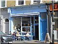
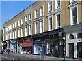
Shops on England's Lane, Belsize Park
Most of the shops on England's Lane have frontages in keeping with the general historic appearance of the buildings in this Conservation Area.
Image: © Kate Jewell
Taken: 30 Mar 2014
0.01 miles
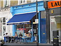
5
Shops and flats on England's Lane, NW3
The southeast side, east of the junction with Belsize Park Gardens, Eton Avenue and Primrose Hill Road.
Image: © Mike Quinn
Taken: 5 Apr 2017
0.01 miles
6
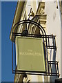
Sign for The Washington, England's Lane, NW3
See Image
Image: © Mike Quinn
Taken: 4 Jul 2011
0.02 miles
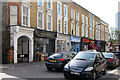
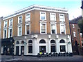
7
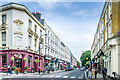
England's Lane
An old lane, marked on the 1851 plan as Ingram's Lane, with the current name shown on the 1871 plan. This latter map shows a few houses, together with Chalcots, a farm owned by Eton College. The rows of buildings seen here are shown on the 1895 edition, with the road now straightened. The pub on the left, the Washington, on the corner of Belsize Park Gardens, is grade II listed - see https://historicengland.org.uk/listing/the-list/list-entry/1078300?section=official-list-entry.
Image: © Ian Capper
Taken: 4 Jun 2022
0.02 miles
8
Sign on The Washington, England's Lane, NW3 (2)
Image: © Mike Quinn
Taken: 5 Jul 2011
0.02 miles
9
Starbucks Coffee cafe on Primrose Hill
This expensive coffee chain is in a converted public house on the junction of England's Lane (on the left) and Primrose Hill (on the right).
Image: © David Anstiss
Taken: 15 Aug 2017
0.02 miles
10
Sign on The Washington, England's Lane / Belsize Park Gardens, NW3
Image: © Mike Quinn
Taken: 5 Apr 2017
0.02 miles