IMAGES TAKEN NEAR TO
Englands Lane, LONDON, NW3 4YA
Introduction
This page details the photographs taken nearby to Englands Lane, NW3 4YA by members of the Geograph project.
The Geograph project started in 2005 with the aim of publishing, organising and preserving representative images for every square kilometre of Great Britain, Ireland and the Isle of Man.

There are currently over 7.5m images from over14,400 individuals and you can help contribute to the project by visiting https://www.geograph.org.uk
Image Map
Images are licensed for reuse under creativecommons.org/licenses/by-sa/2.0
Notes
- Clicking on the map will re-center to the selected point.
- The higher the marker number, the further away the image location is from the centre of the postcode.
Image Listing (279 Images Found)
Images are licensed for reuse under creativecommons.org/licenses/by-sa/2.0
Image
Details
Distance
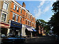
1
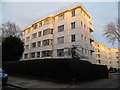
Art deco flats on Englands Lane
The front is on Haverstock Hill
Image: © David Howard
Taken: 15 Feb 2013
0.02 miles
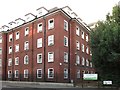
2
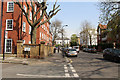
Former Nurses Home, England's Lane
On the north side of England's Lane between Haverstock Hill and Antrim Road this is an imposing Georgian style property constructed over six storeys, formerly nurses accommodation for the nearby Royal Free Hospital. Arranged in two interlinked horseshoe and L-shaped wings, the building provides a series of self contained studio units over ground to fourth floors currently leased to Camden Borough Council. It is understood that this will be developed for private leasehold sale or student accommodation after the Council vacates the property in 2014.
Image: © Kate Jewell
Taken: 30 Mar 2014
0.02 miles
3
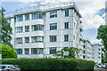
Stanbury Court
Art deco block of flats on the corner of Haverstock Hill and England's Lane, built in 1936 designed by A F A Trehearne of the firm Trehearne and Norman.
Image: © Ian Capper
Taken: 4 Jun 2022
0.02 miles
4
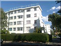
Stanbury Court
A large art-deco style block of flats on the corner of and Haverstock Hill and Englands Lane, NW3.
Image: © David Anstiss
Taken: 15 Aug 2017
0.02 miles
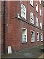
5
(Part of) the former nurses home, England's Lane / Haverstock Hill, NW3 (2)
Shows the location of Image For info about the nurses home, see Image (photographed by Kate Jewell).
Image: © Mike Quinn
Taken: 10 Jul 2018
0.03 miles
6
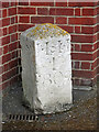
Early 19th C milestone, England's Lane / Haverstock Hill, NW3
Image: © Mike Quinn
Taken: 10 Jul 2018
0.03 miles
7
(Part of) the former nurses home, England's Lane / Haverstock Hill, NW3
Shows the location of Image For info about the nurses home, see Image (photographed by Kate Jewell).
Image: © Mike Quinn
Taken: 10 Jul 2018
0.03 miles
8
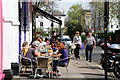
Enjoying lunch on England's Lane, Belsize Park
The sunshine has brought out the diners at one of England's Lane's many cafés and restaurants. the big white house is on Haverstock Hill. England's Lane is the boundary of the Bliss Estate and the Belsize Park Conservation area.
Image: © Kate Jewell
Taken: 30 Mar 2014
0.04 miles
9
England's Lane, NW3 (2)
Between Primrose Hill Gardens and Antrim Road; shows the location of Image
Image: © Mike Quinn
Taken: 4 Jul 2011
0.04 miles
10
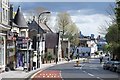
Haverstock Hill, Belsize Park
On the way to Chalk Farm.
Image: © Jim Osley
Taken: 29 Apr 2016
0.04 miles