IMAGES TAKEN NEAR TO
Belsize Grove, LONDON, NW3 4TT
Introduction
This page details the photographs taken nearby to Belsize Grove, NW3 4TT by members of the Geograph project.
The Geograph project started in 2005 with the aim of publishing, organising and preserving representative images for every square kilometre of Great Britain, Ireland and the Isle of Man.

There are currently over 7.5m images from over14,400 individuals and you can help contribute to the project by visiting https://www.geograph.org.uk
Image Map
Images are licensed for reuse under creativecommons.org/licenses/by-sa/2.0
Notes
- Clicking on the map will re-center to the selected point.
- The higher the marker number, the further away the image location is from the centre of the postcode.
Image Listing (244 Images Found)
Images are licensed for reuse under creativecommons.org/licenses/by-sa/2.0
Image
Details
Distance
1
Haverstock Hill
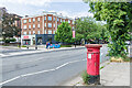
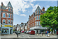
Looking across Haverstock Hill to Belsize Grove and a shopping parade beyond. Belsize Grove was marked on the 1871 25 inch map as Haverstock Grove with the area beyond containing a couple of large houses in substantial grounds together with an even larger house called Woodlands, built in the 1860s by the wine merchant Basil George Woodd for his son Robert Ballard Woodd. By the time of the 1896 6 inch map, Haverstock Grove had been renamed Belsize Grove. Woodlands was demolished in the early 20th Century, but the other houses remained, not being shown as having been replaced until the 1939 25 inch map with the row of shops being marked as Havercourt, the corner building being shown as a bank. Note the Victorian postbox on the right (see Image for a close up).
Image: © Ian Capper
Taken: 4 Jun 2022
0.03 miles
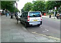
3
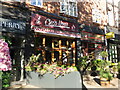
Chez Nous, Haverstock Hill, NW3
Used to be green Image
Image: © Mike Quinn
Taken: 8 Aug 2018
0.04 miles
4
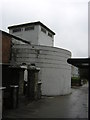
Deep level shelter, Belsize Park
Along the Northern Line at various points, structures like this at street level mark the presence of deep level bomb-shelters, put in position just before the Second World War. Several are used for archive storage now; this one shows no signs of what, if any, its current use is. Other examples can be seen, for instance, at Goodge Street (Image) or Stockwell (Image).
Image: © Christopher Hilton
Taken: 1 Sep 2014
0.04 miles
5
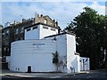
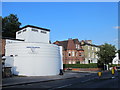
Belsize Park deep shelter (south), Haverstock Hill / Downside Crescent, NW3 (5)
See Image The shelter now sports the logo of "Abbot Datastore" http://www.abbotgroup.co.uk/ .
Image: © Mike Quinn
Taken: 18 Jun 2015
0.05 miles
6
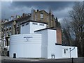
Belsize Park deep shelter (south), Haverstock Hill / Downside Crescent, NW3 (6)
It's had a bit of (much needed) TLC since June 2015 Image
Image: © Mike Quinn
Taken: 6 Apr 2016
0.05 miles
7
Haverstock Hill / Downside Crescent, NW3
Image: © Mike Quinn
Taken: 22 Jul 2016
0.05 miles

9
Electric vehicle charging point in Haverstock Hill
One of a network of charging points which are beginning to appear, this one is provided by Newride London http://www.newride.org.uk/recharge.php
Image: © Rod Allday
Taken: 28 Jun 2011
0.05 miles
10
Howitt Road
Road off Haverstock Hill. The road was developed on the former grounds of a large house called Woodlands, built in the 1860s by the wine merchant Basil George Woodd for his son Robert Ballard Woodd. The house was demolished soon after the latter's death in 1901, with Howitt Road, along with its neighbours Glenloch Road, Glenmore Road and Glenilla Road.
Image: © Ian Capper
Taken: 4 Jun 2022
0.05 miles