IMAGES TAKEN NEAR TO
Eton Road, LONDON, NW3 4SU
Introduction
This page details the photographs taken nearby to Eton Road, NW3 4SU by members of the Geograph project.
The Geograph project started in 2005 with the aim of publishing, organising and preserving representative images for every square kilometre of Great Britain, Ireland and the Isle of Man.

There are currently over 7.5m images from over14,400 individuals and you can help contribute to the project by visiting https://www.geograph.org.uk
Image Map
Images are licensed for reuse under creativecommons.org/licenses/by-sa/2.0
Notes
- Clicking on the map will re-center to the selected point.
- The higher the marker number, the further away the image location is from the centre of the postcode.
Image Listing (361 Images Found)
Images are licensed for reuse under creativecommons.org/licenses/by-sa/2.0
Image
Details
Distance
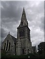
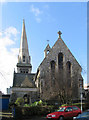
2
View of Saint Saviour's Church from Adelaide Road
Looking northwest.
Image: © Robert Lamb
Taken: 24 Oct 2020
0.01 miles
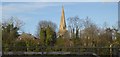
5
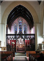
St Saviour, Eton Road, London NW3 - East end
Image: © John Salmon
Taken: 23 Jan 2005
0.03 miles
6
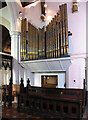
St Saviour, Eton Road, London NW3 - Organ
Image: © John Salmon
Taken: 23 Jan 2005
0.04 miles
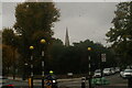
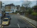
7
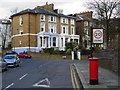
Eton Road, Chalk Farm
Seen from the junction with Adelaide Road. This area was developed in the mid-19th century on land owned by Eton College.
Image: © Stephen McKay
Taken: 27 Feb 2008
0.04 miles
8
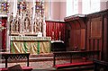
St Saviour, Eton Road, London NW3 - Sanctuary
Image: © John Salmon
Taken: 14 Oct 2001
0.04 miles
10
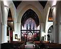
St Saviour, Eton Road, London NW3 - East end
Image: © John Salmon
Taken: 23 Jan 2005
0.04 miles