IMAGES TAKEN NEAR TO
Haverstock Hill, LONDON, NW3 4RS
Introduction
This page details the photographs taken nearby to Haverstock Hill, NW3 4RS by members of the Geograph project.
The Geograph project started in 2005 with the aim of publishing, organising and preserving representative images for every square kilometre of Great Britain, Ireland and the Isle of Man.

There are currently over 7.5m images from over14,400 individuals and you can help contribute to the project by visiting https://www.geograph.org.uk
Image Map
Images are licensed for reuse under creativecommons.org/licenses/by-sa/2.0
Notes
- Clicking on the map will re-center to the selected point.
- The higher the marker number, the further away the image location is from the centre of the postcode.
Image Listing (263 Images Found)
Images are licensed for reuse under creativecommons.org/licenses/by-sa/2.0
Image
Details
Distance
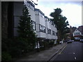
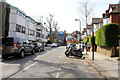
1
Haverstock Hill, Belsize Park
Looking towards Camden.
Image: © Kate Jewell
Taken: 30 Mar 2014
0.02 miles
2

Walham Court, Haverstock Hill, NW3
A rather overpowering red brick block of flats just north of England's Lane which looks as if it was built around the 1970s. This part of the west side of Haverstock Hill is well furnished with similar buildings.
Image: © Kate Jewell
Taken: 30 Mar 2014
0.04 miles
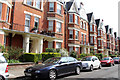
3
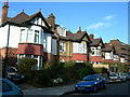
Antrim Road, Belsize Park
Antrim Road was developed in the 1890s, the majority of the buildings being flats. The buildings in the foreground of this photograph were designed to look like semi-detached arts and crafts style houses, while those further away resemble more traditional Victorian terraced villas.
Image: © Kate Jewell
Taken: 30 Mar 2014
0.04 miles
4
Modern houses on Antrim Grove, Belsize Park
Image: © David Howard
Taken: 12 Aug 2009
0.04 miles
5
Antrim Mansions, Belsize Park
Purpose built flats (1897) on Antrim Road.
Image: © Kate Jewell
Taken: 30 Mar 2014
0.05 miles
6
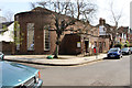
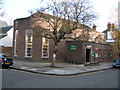
Belsize Community Library
On the corner of Antrim Road and Antrim Grove, to the west of Haverstock Hill, this Library was built in the 1930s to replace the original library which was part of the 1890's building development on Antrim Road. After Camden council withdrew funding it closed early in 2012. It is now run as an independent Community Library by the local children’s and youth development charity, The Winch with the support of the local community. The other community libraries in Camden are Keats Community Library in Keats Grove, Hampstead, and Primrose Hill Community Library in Sharpleshall Street, Primrose Hill.
Image: © Kate Jewell
Taken: 30 Mar 2014
0.05 miles
7
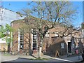
Belsize Community Library, Antrim Road / Antrim Grove, NW3
For info about the library, see Kate Jewell's photo Image
Image: © Mike Quinn
Taken: 5 Apr 2017
0.05 miles
8
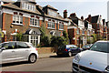
Antrim Grove, Belsize Park
To the west of Haverstock Hill, this road has modern 1970's town houses on the south side and 1920's houses on the north. It links Haverstock Hill to Antrim Road.
Image: © Kate Jewell
Taken: 30 Mar 2014
0.06 miles