IMAGES TAKEN NEAR TO
Lambolle Road, LONDON, NW3 4HS
Introduction
This page details the photographs taken nearby to Lambolle Road, NW3 4HS by members of the Geograph project.
The Geograph project started in 2005 with the aim of publishing, organising and preserving representative images for every square kilometre of Great Britain, Ireland and the Isle of Man.

There are currently over 7.5m images from over14,400 individuals and you can help contribute to the project by visiting https://www.geograph.org.uk
Image Map
Images are licensed for reuse under creativecommons.org/licenses/by-sa/2.0
Notes
- Clicking on the map will re-center to the selected point.
- The higher the marker number, the further away the image location is from the centre of the postcode.
Image Listing (186 Images Found)
Images are licensed for reuse under creativecommons.org/licenses/by-sa/2.0
Image
Details
Distance
5

Blue plaque re Frederick Delius, Belsize Park Gardens, NW3
See Image
Image: © Mike Quinn
Taken: 6 Apr 2016
0.06 miles
6
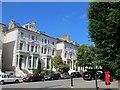
Belsize Park Gardens, NW3
At the junction with Belsize Grove. Shows the location of Image
Image: © Mike Quinn
Taken: 7 Jun 2011
0.06 miles
7
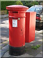
"Anonymous" (Victorian) postbox, Lancaster Drive / Belsize Square, NW3
The high posting aperture dates this postbox to 1879-83.
Image: © Mike Quinn
Taken: 24 Jun 2008
0.07 miles

9
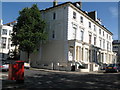
Lancaster Drive, NW3
Shows the location of Image
Image: © Mike Quinn
Taken: 24 Jun 2008
0.07 miles
10
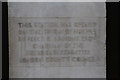
Belsize Fire Station
Engraved stone commemorating the opening of the Fire Station on 22nd May 1915. The station closed on 9th January 2014.
Image: © Martin Addison
Taken: 31 Jan 2015
0.07 miles