IMAGES TAKEN NEAR TO
Quickswood, LONDON, NW3 3RS
Introduction
This page details the photographs taken nearby to Quickswood, NW3 3RS by members of the Geograph project.
The Geograph project started in 2005 with the aim of publishing, organising and preserving representative images for every square kilometre of Great Britain, Ireland and the Isle of Man.

There are currently over 7.5m images from over14,400 individuals and you can help contribute to the project by visiting https://www.geograph.org.uk
Image Map
Images are licensed for reuse under creativecommons.org/licenses/by-sa/2.0
Notes
- Clicking on the map will re-center to the selected point.
- The higher the marker number, the further away the image location is from the centre of the postcode.
Image Listing (212 Images Found)
Images are licensed for reuse under creativecommons.org/licenses/by-sa/2.0
Image
Details
Distance
2
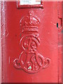
Edward VII postbox, Elsworthy Road, NW3 - royal cipher
See Image
Image: © Mike Quinn
Taken: 12 Jun 2008
0.04 miles
3
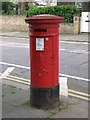
Edward VII postbox, Elsworthy Road, NW3
At the corner with Elsworthy Rise.
Image: © Mike Quinn
Taken: 12 Jun 2008
0.04 miles
4

Chalcots Estate, Primrose Hill area
The blocks that comprise the Chalcots Estate were built in the 1960s to designs prepared by Dennis Lennon Architects, and were renovated between 2004 and 2008.
Image: © Jim Osley
Taken: 17 Nov 2016
0.04 miles
5
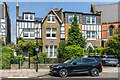
2 & 4 Elsworthy Road
Pair of large semi-detached late Victorian houses in Elsworthy Road. The blue plaque on no 4, on the left, records this as the home of Sir Henry Wood. For a close up see Image
Image: © Ian Capper
Taken: 4 Jun 2022
0.05 miles
6
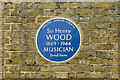
Blue plaque, 4 Elsworthy Road
Blue plaque on the wall of 4 Elsworthy Road, recording this as the home of Sir Henry Wood (he lived here from 1905 to 1937). For a photo of the house, see Image
Image: © Ian Capper
Taken: 4 Jun 2022
0.05 miles
7
The Parish Church of St Mary the Virgin
Looking west along King Henry's Road at junction with Primrose Hill Road. http://www.smvph.org.uk/contact-us.html
Image: © Peter Holmes
Taken: 7 Jun 2008
0.05 miles
8
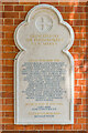
War memorial, Church of St Mary the Virgin, Primrose Hill
War memorial on the Elsworthy Road side of the church of St Mary the Virgin, Primrose Hill (see Image), commemorating 37 parishioners killed in the First World War, 2 in the Second World War and 1 in the Falklands War. The plaque was dedicated on 11 November 2018, supplementing the inscription on the nearby war memorial which had become eroded.
Image: © Ian Capper
Taken: 4 Jun 2022
0.05 miles
9
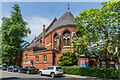
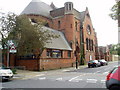
Church of St Mary the Virgin, Primrose Hill
Church on Primrose Hill Road between Elsworthy Road and King Henry's Road. It was built 1870-2, designed by Michael P Manning. It was extended in 1890-2 with the addition of a choir vestry, south aisle and chapel. Grade II listed - see https://historicengland.org.uk/listing/the-list/list-entry/1329902?section=official-list-entry. Just visible on the wall on the far left of the photo is a war memorial plaque - see Image The actual memorial can be part seen on the far right of the photo.
Image: © Ian Capper
Taken: 4 Jun 2022
0.05 miles