IMAGES TAKEN NEAR TO
Parkhill Road, LONDON, NW3 2YG
Introduction
This page details the photographs taken nearby to Parkhill Road, NW3 2YG by members of the Geograph project.
The Geograph project started in 2005 with the aim of publishing, organising and preserving representative images for every square kilometre of Great Britain, Ireland and the Isle of Man.

There are currently over 7.5m images from over14,400 individuals and you can help contribute to the project by visiting https://www.geograph.org.uk
Image Map
Images are licensed for reuse under creativecommons.org/licenses/by-sa/2.0
Notes
- Clicking on the map will re-center to the selected point.
- The higher the marker number, the further away the image location is from the centre of the postcode.
Image Listing (269 Images Found)
Images are licensed for reuse under creativecommons.org/licenses/by-sa/2.0
Image
Details
Distance
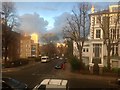
1
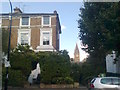
House on Parkhill Road
In the background is the clock tower of St Dominics Priory.
Image: © David Anstiss
Taken: 15 Aug 2017
0.04 miles
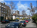
2
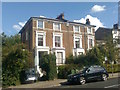
Housing on Parkhill Road
Thought these houses along the road could be Grade II listed houses, but found out later these are not.
Image: © David Anstiss
Taken: 15 Aug 2017
0.04 miles
4
Blinding reflection, Upper Park Road, Belsize Park
Late afternoon sun lighting up the top floor window on one of the large semi-detached houses on Upper Park Road. These Edwardian villas are now mostly converted into apartments. This photograph was taken from a first floor apartment window on the opposite side of the road.
Image: © Kate Jewell
Taken: 28 Jan 2017
0.05 miles
6
Late afternoon sun on Tasker Road, Belsize Park
Looking up Tasker Road from 1st floor of Upper Park Road apartment. The large Edwardian house on the right is on Upper Park Road.
Image: © Kate Jewell
Taken: 28 Jan 2017
0.05 miles
7

Parkhill Road, NW3 (2)
Shows the location of Image
Image: © Mike Quinn
Taken: 1 Oct 2008
0.06 miles
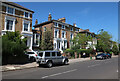
8
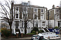
34 and 36, Upper Park Road, Belsize Park
Semi-detached Victorian villas by the junction of Tasker Road and Upper Park Road, showing the original structure (apart from the dormer window in the roof of No 36). A conversion of a coach house at the side of No 34 is indicated by the scaffolding. These were probably some of the last houses to be built (1860) in the first phase of development on Upper Park Road.
Image: © Kate Jewell
Taken: 30 Mar 2014
0.06 miles
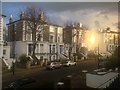
9
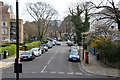
Tasker Road, Belsize Park
This is one of the two cross routes from Upper Park Road to Park Hill Road. Previously known as Church Road it was renamed in 1937 after Countess Tasker, benefactress of St Dominic's Priory Church, which was built in 1883. The church can be seen through the trees in the centre of the photograph.
Image: © Kate Jewell
Taken: 30 Mar 2014
0.06 miles
