IMAGES TAKEN NEAR TO
South Hill Park, LONDON, NW3 2SH
Introduction
This page details the photographs taken nearby to South Hill Park, NW3 2SH by members of the Geograph project.
The Geograph project started in 2005 with the aim of publishing, organising and preserving representative images for every square kilometre of Great Britain, Ireland and the Isle of Man.

There are currently over 7.5m images from over14,400 individuals and you can help contribute to the project by visiting https://www.geograph.org.uk
Image Map
Images are licensed for reuse under creativecommons.org/licenses/by-sa/2.0
Notes
- Clicking on the map will re-center to the selected point.
- The higher the marker number, the further away the image location is from the centre of the postcode.
Image Listing (334 Images Found)
Images are licensed for reuse under creativecommons.org/licenses/by-sa/2.0
Image
Details
Distance
1
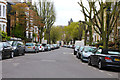
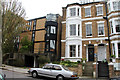
South Hill Park. Belsize Park, NW3
An eclectic mix of styles in this Conservation Area: Victorian villas interspersed with post World War 2 infill and 19th Century shops in the centre distance.The tower of St John's Church on Downshire Hill is on the horizon, see Image
Image: © Kate Jewell
Taken: 31 Mar 2014
0.01 miles
2
South Hill Park, NW3
Shows the location of Image
Image: © Mike Quinn
Taken: 30 Oct 2008
0.02 miles
4
South Hill Park / Parliament Hill, NW3
Shows the location of Image
Image: © Mike Quinn
Taken: 30 Oct 2008
0.04 miles
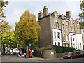
5
Two periods of architecture on South Hill Park, NW3
Modern houses designed by Brawne (No.31 in 1952) and Ingersoll (No.29 in 1963) sit comfortably with traditional Victorian villas.
Image: © Kate Jewell
Taken: 31 Mar 2014
0.04 miles
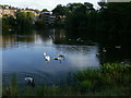
8
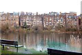
Pond in Hampstead Heath #3
Looking east-southeast toward the backs of the houses on South Hill Park.
Image: © Robert Lamb
Taken: 27 Jul 2010
0.04 miles

10
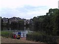
Hampstead Heath: East Heath Road
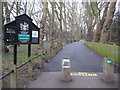
This is the southernmost part of the Corporation of London-owned Hampstead Heath where a newly resurfaced footpath leads up from Hampstead Heath railway station through an avenue of London plane trees to the three Hampstead ponds and East Heath. The 1871 edition of the Ordnance Survey's mapping shows that this footpath runs across the site of a fourth pond which extended from the Parliament Hill road right up to the base of the dam of what is now Pond Number 1. When the London County Council acquired the pond in 1892 they filled it in to provide a grassy approach to the heath from the station, and it is not shown on the 1896 edition of the Ordnance Survey's mapping.
On Easter Monday 1892 it was estimated, according to a contemporary newspaper report, that about a hundred thousand people visited Hampstead Heath, most of them travelling by train from London's East End. At the end of the day a heavy rain storm threatened and 2 women and 6 children were killed, and many more were injured, in a crush at Hampstead Heath railway station as day-trippers hurried to catch their trains. Is it possible that this disaster and the desire to have a larger space at the approach to the station were some of the reasons why the pond was filled in?
Image: © Nigel Cox
Taken: 14 Feb 2010
0.04 miles