IMAGES TAKEN NEAR TO
South End Road, LONDON, NW3 2QE
Introduction
This page details the photographs taken nearby to South End Road, NW3 2QE by members of the Geograph project.
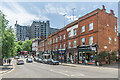
The Geograph project started in 2005 with the aim of publishing, organising and preserving representative images for every square kilometre of Great Britain, Ireland and the Isle of Man.

There are currently over 7.5m images from over14,400 individuals and you can help contribute to the project by visiting https://www.geograph.org.uk
Image Map
Images are licensed for reuse under creativecommons.org/licenses/by-sa/2.0
Notes
- Clicking on the map will re-center to the selected point.
- The higher the marker number, the further away the image location is from the centre of the postcode.
Image Listing (326 Images Found)
Images are licensed for reuse under creativecommons.org/licenses/by-sa/2.0
Image
Details
Distance
1
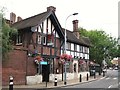
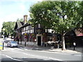
The Garden Gate, South End Road, NW3
The pub used to be called the Railway Tavern - it's only 50 m from Hampstead Heath station.
Image: © Mike Quinn
Taken: 30 Jul 2010
0.00 miles
2
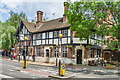
The Garden Gate
Mid 19th Century pub in South End Road next to Hampstead Heath Station on the North London Line, originally called the Perseverance, then by 1874 the Railway Tavern and by 2010 its present name.
Image: © Ian Capper
Taken: 4 Jun 2022
0.00 miles
3
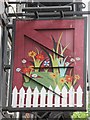
Sign for the Garden Gate, South End Road, NW3
See Image
Image: © Mike Quinn
Taken: 30 Jul 2010
0.01 miles
4
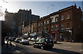
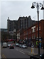
South End Road
Looking towards South End Green from the junction with St. Crispins Close. The parade of shops is dwarfed by the Royal Free Hospital behind.
Image: © Martin Addison
Taken: 1 Feb 2008
0.01 miles
5
The Garden Gate public house, Hampstead Heath
South End Road, London, NW3.
Image: © JThomas
Taken: 3 Sep 2016
0.01 miles
6
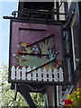
Sign for the Garden Gate public house, Hampstead Heath
Image: © JThomas
Taken: 3 Sep 2016
0.01 miles
7
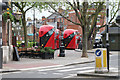
New red buses
Waiting to pick up passengers on South End Green, Belsize Park, NW3
Image: © Kate Jewell
Taken: 31 Mar 2014
0.02 miles
8
South End Road NW3
At the junction with St Crispin's Close
Image: © Robin Sones
Taken: 4 Jan 2012
0.02 miles
9
South End Lane
A row of late 19th Century (in the foreground) and early 20th Century (beyond) buildings in South End Road, with the Royal Free Hospital in the background.
Image: © Ian Capper
Taken: 4 Jun 2022
0.02 miles
10
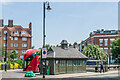
Tramwaymen's shelter, South End Green
Former tramwaymen's shelter in South End Green built in the 1890s, with South End Green having become the terminus of the London Tramway Company's tram route in c.1886. Grade II listed - see https://historicengland.org.uk/listing/the-list/list-entry/1380563?section=official-list-entry. On the right of the photo are the railings and gate at the top of the stairs leading down to some underground public conveniences. Dating from 1897 they are also grade II listed - see https://historicengland.org.uk/listing/the-list/list-entry/1378671?section=official-list-entry.
Image: © Ian Capper
Taken: 4 Jun 2022
0.02 miles