IMAGES TAKEN NEAR TO
Ella Mews, LONDON, NW3 2NH
Introduction
This page details the photographs taken nearby to Ella Mews, NW3 2NH by members of the Geograph project.
The Geograph project started in 2005 with the aim of publishing, organising and preserving representative images for every square kilometre of Great Britain, Ireland and the Isle of Man.

There are currently over 7.5m images from over14,400 individuals and you can help contribute to the project by visiting https://www.geograph.org.uk
Image Map
Images are licensed for reuse under creativecommons.org/licenses/by-sa/2.0
Notes
- Clicking on the map will re-center to the selected point.
- The higher the marker number, the further away the image location is from the centre of the postcode.
Image Listing (316 Images Found)
Images are licensed for reuse under creativecommons.org/licenses/by-sa/2.0
Image
Details
Distance
1
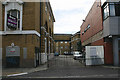
Entrance to former Hampstead tram depot, Cressy Road, NW3
Between the 1880s and 1938 the road behind the gates, now Ella Mews, served as the entrance to Hampstead tram depot. The depot began as a horse tram facility in around 1887. It was operated by the London Street Tramway Company later acquired by the North Metropolitan Tramway Company which was itself sold to the London County Council in 1905 around which time the Hampstead tram routes were electrified. The depot closed in 1938 when trolleybuses replaced the trams but the premises kept their public transport connection until around 1946 albeit as a storage facility. The main part of the depot was to the right behind what is now the Roy Shaw Centre. Although the building to the left has a tramway look about it, that does not prove beyond doubt that it formed part of the depot.
Image: © David Kemp
Taken: 1 Jul 2019
0.00 miles
2
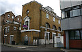
Entrance to former Hampstead tram depot, Cressy Road, NW3
Between the 1880s and 1938 the road behind the gates, now Ella Mews, served as the entrance to Hampstead tram depot. The depot began as a horse tram facility in around 1887. It was operated by the London Street Tramway Company later acquired by the North Metropolitan Tramway Company which was itself sold to the London County Council in 1905 around which time the Hampstead tram routes were electrified. The depot closed in 1938 when trolleybuses replaced the trams but the premises kept their public transport connection until around 1946 albeit as a storage facility. Although the building just to the left of the gates has a tramway look about it, that does not prove beyond doubt that it formed part of the depot which extended to the right behind the modern building in the foreground.
Image: © David Kemp
Taken: 1 Jul 2019
0.01 miles
4
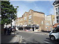
The Roy Shaw Centre, Cressy Road, NW3
The building houses London Borough of Camden offices and is named after the late Roy Shaw, a long-serving local councillor. Ella Mews, the gated road to the left, leads to the site of the former Hampstead tram depot which closed for operational purposes in 1938 and extended behind the Centre.
Image: © David Kemp
Taken: 1 Jul 2019
0.01 miles
6
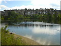
Hampstead Number 1 pond
One of several man-made ponds on Hampstead Heath
Image: © dg
Taken: 29 Jul 2005
0.02 miles
7
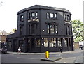
The Stag public house, London SW3
On Fleet Road.
Image: © JThomas
Taken: 3 Sep 2016
0.03 miles
8

The Stag, Hampstead
Corner of Fleet Road and Lawn Road.
Image: © Natasha Ceridwen de Chroustchoff
Taken: 26 Jan 2008
0.03 miles
9
The Stag
At the junction of Fleet Road and Lawn Road, NW3; shows the location of Image
Image: © Mike Quinn
Taken: 2 Jul 2008
0.03 miles
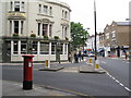
10
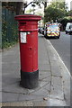
Postbox on Fleet Road, London NW3
Postbox No. NW3 38.
Image: © JThomas
Taken: 3 Sep 2016
0.04 miles