IMAGES TAKEN NEAR TO
Savernake Road, LONDON, NW3 2JR
Introduction
This page details the photographs taken nearby to Savernake Road, NW3 2JR by members of the Geograph project.
The Geograph project started in 2005 with the aim of publishing, organising and preserving representative images for every square kilometre of Great Britain, Ireland and the Isle of Man.

There are currently over 7.5m images from over14,400 individuals and you can help contribute to the project by visiting https://www.geograph.org.uk
Image Map
Images are licensed for reuse under creativecommons.org/licenses/by-sa/2.0
Notes
- Clicking on the map will re-center to the selected point.
- The higher the marker number, the further away the image location is from the centre of the postcode.
Image Listing (245 Images Found)
Images are licensed for reuse under creativecommons.org/licenses/by-sa/2.0
Image
Details
Distance
1
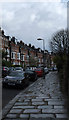
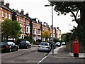
Savernake Road
Large semi-detached town houses and rough-hewn paving slabs showing signs of recent rain.
Image: © Martin Addison
Taken: 23 Mar 2014
0.01 miles
2
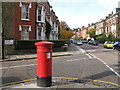
Savernake Road / Rona Road, NW3
Shows the location of Image
Image: © Mike Quinn
Taken: 30 Oct 2008
0.01 miles
3
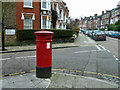
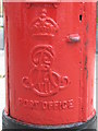
Late Victorian pillar box, Rona Road
At the corner with Savernake Road. The bracket on top suggests there once was a sign pointing to the nearest post office. This would have been a modification, 1920s or later. The front panel now directs to where a later collection is made: Hampstead Delivery Office, Shepherds Walk.
Image: © Robin Webster
Taken: 29 Jan 2011
0.02 miles
4
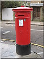
Victorian postbox, Savernake Road / Rona Road, NW3
This postbox appears to have the (scant) remains of a "post office direction sign" on top of the crown. The location of this postbox is shown in Image and Image
Image: © Mike Quinn
Taken: 30 Oct 2008
0.04 miles
5
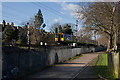
Gospel Oak Junction
313109 approaches Gospel Oak from South Hampstead. The footpath, lined with Plane trees, follows the line of the railway between Parliament Hill Lido and the footbridge to Savernake Road. The Gospel Oak Junction sign has received the attentions of the local youths and is barely legible.
Image: © Martin Addison
Taken: 1 Feb 2008
0.04 miles
7
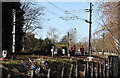
Checking the Tracks
Two members of the permanent way gang check for loose clips holding the rails on the North London Line at Gospel Oak Junction. One was acting as lookout and the other was hammering loose clips home.
Image: © Martin Addison
Taken: 1 Feb 2008
0.06 miles
8
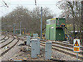
Gospel Oak signal box
This must be a contender for the ugliest signal box on the British railway network.
Image: © Alan Murray-Rust
Taken: 12 Feb 2009
0.06 miles
9
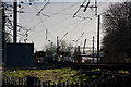
Gospel Oak Junction
Looking towards Gospel Oak Station. The train on the right is going towards Stratford whilst the one on the left is in the bay platform for Barking. In the foreground are discarded point frogs cut out during past track relaying operations.
Image: © Martin Addison
Taken: 1 Feb 2008
0.08 miles
10
Edward VII postbox, Mansfield Road / Estelle Road, NW3 - royal cipher
See Image
Image: © Mike Quinn
Taken: 30 Oct 2008
0.08 miles