IMAGES TAKEN NEAR TO
Aspern Grove, LONDON, NW3 2BX
Introduction
This page details the photographs taken nearby to Aspern Grove, NW3 2BX by members of the Geograph project.
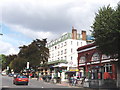
The Geograph project started in 2005 with the aim of publishing, organising and preserving representative images for every square kilometre of Great Britain, Ireland and the Isle of Man.

There are currently over 7.5m images from over14,400 individuals and you can help contribute to the project by visiting https://www.geograph.org.uk
Image Map
Images are licensed for reuse under creativecommons.org/licenses/by-sa/2.0
Notes
- Clicking on the map will re-center to the selected point.
- The higher the marker number, the further away the image location is from the centre of the postcode.
Image Listing (261 Images Found)
Images are licensed for reuse under creativecommons.org/licenses/by-sa/2.0
Image
Details
Distance
1
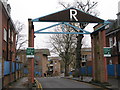
Aspern Grove, NW3
The estate was built on the site of the former Russell Nurseries; photo shows the location of Image
Image: © Mike Quinn
Taken: 26 Nov 2008
0.02 miles
2
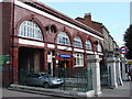
Belsize Park tube station
This station is on the Edgware branch of the Northern Line, between Chalk Farm and Hampstead stations. Belsize Park is one of eight London Underground stations which has a deep-level air-raid shelter underneath it. The shelter was constructed in World War II to provide safe accommodation for service personnel. It is also the only London Underground station with a "z" in its name.
Image: © Oxyman
Taken: 29 Aug 2007
0.02 miles
3
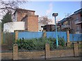
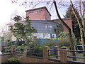
Belsize Park deep shelter (north) behind Allingham Court, NW3 (2)
In late 1940, the government decided to build a system of deep (air raid) shelters linked to existing underground stations. Each deep shelter consisted of two parallel tubes that might be used for future express underground lines. Seven such shelters were built at Northern Line stations - Belsize Park, Camden Town, Goodge Street, Stockwell, Clapham North, Clapham Common and Clapham South. Each shelter had two entrances with a “pill box” and ventilation shafts; most of these are still there today (February 2011). Some of the deep shelters are in use for secure storage of documents.
This shelter can be seen on the satellite image http://wtp2.appspot.com/wheresthepath.htm?lat=51.55134382506979&lon=-0.16482040286064148&gz=20&oz=10>=1.[Source: “Beneath the City Streets” by Peter Laurie (1970, revised 1979).]
See also Image and Image
Image: © Mike Quinn
Taken: 8 Feb 2011
0.02 miles
4
Belsize Park Underground Station
Belsize Park Underground Station on Haverstock Hill
Image: © Shaun Ferguson
Taken: 24 Apr 2008
0.02 miles
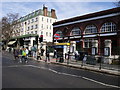
5
Haverstock Hill
The underground station on the right of the photo is Belsize Park.
Image: © David Hawgood
Taken: 20 Aug 2005
0.03 miles
6
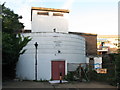
Belsize Park deep shelter (north) behind Allingham Court, NW3 (3)
In late 1940, the government decided to build a system of deep (air raid) shelters linked to existing underground stations. Each deep shelter consisted of two parallel tubes that might be used for future express underground lines. Seven such shelters were built at Northern Line stations - Belsize Park, Camden Town, Goodge Street, Stockwell, Clapham North, Clapham Common and Clapham South. Each shelter had two entrances with a “pill box” and ventilation shafts; most of these are still there today (February 2011). Some of the deep shelters are in use for secure storage of documents.
This shelter can be seen on the satellite image http://wtp2.appspot.com/wheresthepath.htm?lat=51.55134382506979&lon=-0.16482040286064148&gz=20&oz=10>=1. [Source: “Beneath the City Streets” by Peter Laurie (1970, revised 1979).]
Image: © Mike Quinn
Taken: 8 Feb 2011
0.03 miles
7
Belsize Park deep shelter (north) behind Allingham Court, NW3
In late 1940, the government decided to build a system of deep (air raid) shelters linked to existing underground stations. Each deep shelter consisted of two parallel tubes that might be used for future express underground lines. Seven such shelters were built at Northern Line stations - Belsize Park, Camden Town, Goodge Street, Stockwell, Clapham North, Clapham Common and Clapham South. Each shelter had two entrances with a “pill box” and ventilation shafts; most of these are still there today (February 2011). Some of the deep shelters are in use for secure storage of documents.
This shelter can be seen on the satellite image http://wtp2.appspot.com/wheresthepath.htm?lat=51.55134382506979&lon=-0.16482040286064148&gz=20&oz=10>=1. [Source: “Beneath the City Streets” by Peter Laurie (1970, revised 1979).]
See also Image
Image: © Mike Quinn
Taken: 31 Jul 2010
0.03 miles
8
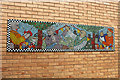
Mosaic Murals in the Russell Nurseries Estate (3)
Created by Rise Phoenix. They are a London-based charity which, since 1994, has enabled professional artists to work with disadvantaged groups and young people in the UK and abroad.
Image: © Kate Jewell
Taken: 31 Mar 2014
0.04 miles
9
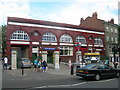
Belsize Park Station
Situated on Haverstock Hill, London NW3
Image: © Robin Sones
Taken: 31 Jul 2007
0.04 miles
10
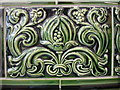
Decorative tile in Belsize Park tube station
This tile is in the booking office of Belsize Park tube station.
Image: © Oxyman
Taken: 29 Aug 2007
0.04 miles