IMAGES TAKEN NEAR TO
Haverstock Hill, LONDON, NW3 2BB
Introduction
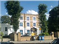
This page details the photographs taken nearby to Haverstock Hill, NW3 2BB by members of the Geograph project.
The Geograph project started in 2005 with the aim of publishing, organising and preserving representative images for every square kilometre of Great Britain, Ireland and the Isle of Man.

There are currently over 7.5m images from over14,400 individuals and you can help contribute to the project by visiting https://www.geograph.org.uk
Image Map
Images are licensed for reuse under creativecommons.org/licenses/by-sa/2.0
Notes
- Clicking on the map will re-center to the selected point.
- The higher the marker number, the further away the image location is from the centre of the postcode.
Image Listing (292 Images Found)
Images are licensed for reuse under creativecommons.org/licenses/by-sa/2.0
Image
Details
Distance
1
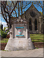
Boundary market, Maitland Park Estate
History of this estate at this http://hidden-london.com/gazetteer/maitland-park/.
Image: © Jim Osley
Taken: 29 Apr 2016
0.00 miles
2
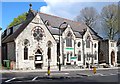
Seventh Day Adventist Church, Haverstock Hill
Built in 1877 as Oxenden Presbyterian Church to the designs of architect Thomas Arnold.
Ref: The Buildings of England. London 4: North (1998), p. 208
Image: © Jim Osley
Taken: 29 Apr 2016
0.00 miles
3
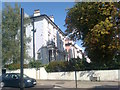
Houses on Haverstock Road
As seen from Parkhill Road.
Image: © David Anstiss
Taken: 15 Aug 2017
0.02 miles
4
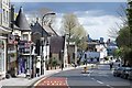
Haverstock Hill, Belsize Park
On the way to Chalk Farm.
Image: © Jim Osley
Taken: 29 Apr 2016
0.02 miles
5
The Village School, Maitland Park
Converted large house on Parkhill Road, now a Preparatory school for Girls.
Image: © David Anstiss
Taken: 15 Aug 2017
0.03 miles
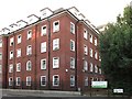
6
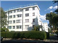
Stanbury Court
A large art-deco style block of flats on the corner of and Haverstock Hill and Englands Lane, NW3.
Image: © David Anstiss
Taken: 15 Aug 2017
0.04 miles
7

Stanbury Court
Art deco block of flats on the corner of Haverstock Hill and England's Lane, built in 1936 designed by A F A Trehearne of the firm Trehearne and Norman.
Image: © Ian Capper
Taken: 4 Jun 2022
0.04 miles
8
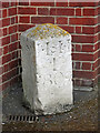
Early 19th C milestone, England's Lane / Haverstock Hill, NW3
Image: © Mike Quinn
Taken: 10 Jul 2018
0.04 miles
9
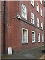
(Part of) the former nurses home, England's Lane / Haverstock Hill, NW3
Shows the location of Image For info about the nurses home, see Image (photographed by Kate Jewell).
Image: © Mike Quinn
Taken: 10 Jul 2018
0.04 miles
10
(Part of) the former nurses home, England's Lane / Haverstock Hill, NW3 (2)
Shows the location of Image For info about the nurses home, see Image (photographed by Kate Jewell).
Image: © Mike Quinn
Taken: 10 Jul 2018
0.04 miles