IMAGES TAKEN NEAR TO
Randall Avenue, LONDON, NW2 7SY
Introduction
This page details the photographs taken nearby to Randall Avenue, NW2 7SY by members of the Geograph project.
The Geograph project started in 2005 with the aim of publishing, organising and preserving representative images for every square kilometre of Great Britain, Ireland and the Isle of Man.

There are currently over 7.5m images from over14,400 individuals and you can help contribute to the project by visiting https://www.geograph.org.uk
Image Map
Images are licensed for reuse under creativecommons.org/licenses/by-sa/2.0
Notes
- Clicking on the map will re-center to the selected point.
- The higher the marker number, the further away the image location is from the centre of the postcode.
Image Listing (46 Images Found)
Images are licensed for reuse under creativecommons.org/licenses/by-sa/2.0
Image
Details
Distance
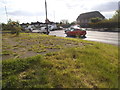
1
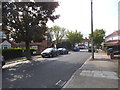
The North Circular Road looking towards Randall Avenue
Image: © David Howard
Taken: 27 Feb 2014
0.07 miles
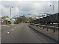
2
A406 North Circular at Neasden
Taken from a footbridge, looking South towards Neasden. See Image for a view from this bridge to the Welsh Harp.
Image: © David Hawgood
Taken: 5 Oct 2005
0.07 miles
3
Footbridge across the North Circular Road, Neasden
Image: © David Howard
Taken: 26 May 2015
0.07 miles
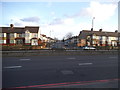
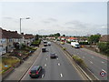
5
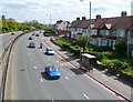
Bus shelter and houses, North Circular Road, Neasden
Viewed from this http://www.geograph.org.uk/photo/3071639 footbridge. The turning beyond the bus stop is into Randall Avenue. The twin pinkish lines at the pavement edge indicate a Red Route. Apart from a few exceptions, vehicles are not allowed to stop on a Red Route. This restriction includes stopping to load or unload, or to board or alight from a vehicle (except for buses at a bus stop such as here, licensed taxis and the holders of blue badges). The double lines mean that these restrictions apply at all times and on all days. A single red line is used where the prohibition applies only during times displayed on nearby signs.
Image: © Jaggery
Taken: 13 May 2012
0.08 miles
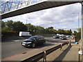
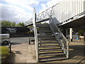
7
North Circular Road (A406) - Kenwyn Drive footbridge
Image: © Peter Whatley
Taken: 3 Apr 2012
0.08 miles
8
The North Circular Road, Neasden
Looking towards the old library, which is now on Neasden Lane
Image: © David Howard
Taken: 26 May 2015
0.08 miles
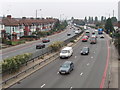
9
North Circular Road, Neasden
View from a foot bridge.
The A406.
Image: © JThomas
Taken: 3 Aug 2019
0.09 miles