IMAGES TAKEN NEAR TO
Lovat Close, LONDON, NW2 7RU
Introduction
This page details the photographs taken nearby to Lovat Close, NW2 7RU by members of the Geograph project.
The Geograph project started in 2005 with the aim of publishing, organising and preserving representative images for every square kilometre of Great Britain, Ireland and the Isle of Man.

There are currently over 7.5m images from over14,400 individuals and you can help contribute to the project by visiting https://www.geograph.org.uk
Image Map
Images are licensed for reuse under creativecommons.org/licenses/by-sa/2.0
Notes
- Clicking on the map will re-center to the selected point.
- The higher the marker number, the further away the image location is from the centre of the postcode.
Image Listing (97 Images Found)
Images are licensed for reuse under creativecommons.org/licenses/by-sa/2.0
Image
Details
Distance
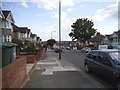
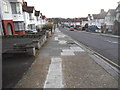
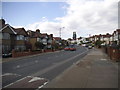
4
Dollis Hill Lane at the junction of Park View Road
Image: © David Howard
Taken: 26 May 2015
0.07 miles
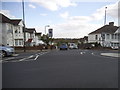
7
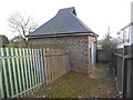
Electricity substation on Dollis Hill Lane
Image: © David Howard
Taken: 22 Jan 2014
0.09 miles
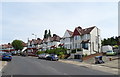
8
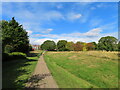
Gladstone Park Willesden, view to north-west corner
View along path. Houses beyond are in Dollis Hill Lane. There are fine belts of trees in the park, and large areas of grass are kept rough.
Image: © David Hawgood
Taken: 15 Oct 2021
0.09 miles