IMAGES TAKEN NEAR TO
Ashcombe Park, LONDON, NW2 7QT
Introduction
This page details the photographs taken nearby to Ashcombe Park, NW2 7QT by members of the Geograph project.
The Geograph project started in 2005 with the aim of publishing, organising and preserving representative images for every square kilometre of Great Britain, Ireland and the Isle of Man.

There are currently over 7.5m images from over14,400 individuals and you can help contribute to the project by visiting https://www.geograph.org.uk
Image Map
Images are licensed for reuse under creativecommons.org/licenses/by-sa/2.0
Notes
- Clicking on the map will re-center to the selected point.
- The higher the marker number, the further away the image location is from the centre of the postcode.
Image Listing (109 Images Found)
Images are licensed for reuse under creativecommons.org/licenses/by-sa/2.0
Image
Details
Distance
2
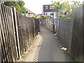
Path from Tanfield Avenue to Cairnfield Avenue
Image: © David Howard
Taken: 26 May 2015
0.08 miles
3
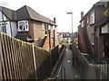
Path from Tanfield Avenue to Cairnfield Avenue
Image: © David Howard
Taken: 26 May 2015
0.09 miles
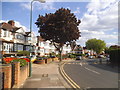
5
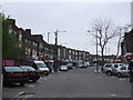
Randall Avenue, Neasden
From the junction of Crest Road on Dollis Hill, looking North. The two men with orange bags walking up the pavement are delivering "junk mail" advertising or free newspapers.
Image: © David Hawgood
Taken: 5 Oct 2005
0.10 miles
6
Tanfield Avenue at the junction of Kenwyn Drive
Image: © David Howard
Taken: 26 May 2015
0.11 miles
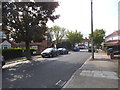
9
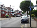
Tanfield Avenue, London NW2
Parking Permitted Partially on Footway.
Image: © JThomas
Taken: 3 Aug 2019
0.12 miles