IMAGES TAKEN NEAR TO
Coles Green Road, LONDON, NW2 7JL
Introduction
This page details the photographs taken nearby to Coles Green Road, NW2 7JL by members of the Geograph project.
The Geograph project started in 2005 with the aim of publishing, organising and preserving representative images for every square kilometre of Great Britain, Ireland and the Isle of Man.

There are currently over 7.5m images from over14,400 individuals and you can help contribute to the project by visiting https://www.geograph.org.uk
Image Map
Images are licensed for reuse under creativecommons.org/licenses/by-sa/2.0
Notes
- Clicking on the map will re-center to the selected point.
- The higher the marker number, the further away the image location is from the centre of the postcode.
Image Listing (56 Images Found)
Images are licensed for reuse under creativecommons.org/licenses/by-sa/2.0
Image
Details
Distance
1
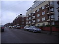
Flats along Coles Green Road, Dollis Hill
The near block is called Kelceda
Image: © David Howard
Taken: 11 Feb 2011
0.04 miles
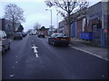
2
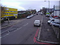
Coles Green Road
Taken from the footbridge over the North Circular Road.
Image: © David Howard
Taken: 8 Dec 2009
0.06 miles
3
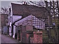
Oxgate Farm, Coles Green Road
This 16th and 17th century former manor house on an older site, the oldest house in the borough of Brent, is getting some loving care at last according to https://www.facebook.com/OxgateFarm after its plight was remarked on in http://spitalfieldslife.com/2014/08/01/at-oxgate-farm/ .
Image: © Chris Brown
Taken: 1 Apr 2018
0.09 miles
4
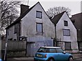
Oxgate Farm
The former manor house on Coles Green Road, the oldest house in the borough of Brent, is getting some loving care at last according to https://www.facebook.com/OxgateFarm after its plight was remarked on in http://spitalfieldslife.com/2014/08/01/at-oxgate-farm/ .
Image: © Chris Brown
Taken: 1 Apr 2018
0.09 miles
5
Waterloo Road
Part of the small industrial area at Staples Corner.
Image: © David Howard
Taken: 8 Dec 2009
0.10 miles
7
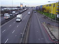
Staples Corner flyover
In the 60s this was a crossroads with traffic lights, this solved the problem soon afterwards.
Image: © David Howard
Taken: 8 Dec 2009
0.13 miles
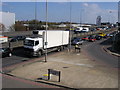
8
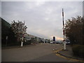
Business Park, 1000 North Circular Road
Image: © David Howard
Taken: 3 Nov 2015
0.13 miles
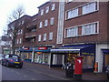
9
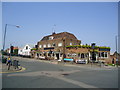
The Ox and Gate public house, Dollis Hill
Image: © Stacey Harris
Taken: 30 Apr 2011
0.14 miles
10
North Circular Road
North Circular Road passing Coles Green Road
Image: © Shaun Ferguson
Taken: 1 Apr 2009
0.14 miles