IMAGES TAKEN NEAR TO
Woodbridge Close, LONDON, NW2 6YN
Introduction
This page details the photographs taken nearby to Woodbridge Close, NW2 6YN by members of the Geograph project.
The Geograph project started in 2005 with the aim of publishing, organising and preserving representative images for every square kilometre of Great Britain, Ireland and the Isle of Man.

There are currently over 7.5m images from over14,400 individuals and you can help contribute to the project by visiting https://www.geograph.org.uk
Image Map
Images are licensed for reuse under creativecommons.org/licenses/by-sa/2.0
Notes
- Clicking on the map will re-center to the selected point.
- The higher the marker number, the further away the image location is from the centre of the postcode.
Image Listing (28 Images Found)
Images are licensed for reuse under creativecommons.org/licenses/by-sa/2.0
Image
Details
Distance
1
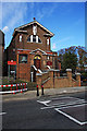
Church of St. Mary and St. Andrew
Located on Dollis Hill Lane. The church was built in 1933 and a side chapel was added by 1978. In August 1982 Fr Maloney procured for the parish the bell, specially cast for the Papal Mass at Coventry, and installed it in the small tower at the front of the church - visible on the left side of the entrance door. A fuller history can be found at http://www.stmaryandstandrew.co.uk/history.html..
Image: © Martin Addison
Taken: 23 Oct 2009
0.09 miles
2
Church of St Mary and St Andrew
A Roman Catholic church on Dollis Hill Lane.
Image: © Robin Webster
Taken: 26 Feb 2011
0.10 miles
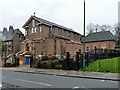
3
Church and Presbytery
The Church of St Mary and St Andrew with the church house next door.
Image: © Des Blenkinsopp
Taken: 8 Jun 2016
0.12 miles
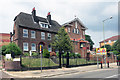
4
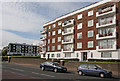
Neville's Court
Located on Dollis Hill Lane, approximately 200yds from the one time Post Office Research Station. In 1939 work started on an alternative cabinet war room within the grounds of the research station called Paddock. There was no accommodation on site, so it was proposed that 60 flats in Neville's court would be used for housing war cabinet senior staff and secretaries. After the start of the London Blitz on 7th September 1940, Churchill visited the site and approved plans to knock two of the flats into one to form a double flat for himself and his secretaries. One week later the Office of Works requisitioned the whole of Neville's Court for the Government.
information from Subterranea Britannica - see http://www.subbrit.org.uk/sb-sites/sites/p/paddock/index.shtml for the full story of Paddock.
Image: © Martin Addison
Taken: 23 Oct 2009
0.12 miles
6
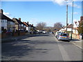
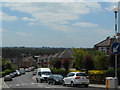
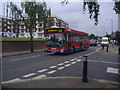
Brook Road, Dollis Hill
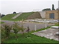
Brook Road rises up from Gladstone Park and Dollis Hill Lane to pass the covered Dollis Hill Reservoir before descending here to eventually meet the North Circular Road. This view is to the open land around the Brent Reservoir with Kingsbury beyond.
Image: © Marathon
Taken: 4 Mar 2015
0.15 miles
7
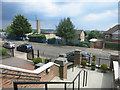
View from the Church Steps
This is outside the door of St Mary's and St Andrew's Church, where you get an idea of how relatively high up this area is.
Only 75 - 80 metres, but considerably higher than a lot of London.
Image: © Des Blenkinsopp
Taken: 8 Jun 2016
0.15 miles
8
Dollis Hill Reservoir
Water supply for London, at the top of Dollis Hill
Image: © David Hawgood
Taken: 5 Oct 2005
0.15 miles
9
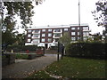
Neville Court on Dollis Hill Lane
By Gladstone Park exit
Image: © David Howard
Taken: 1 Oct 2014
0.17 miles