IMAGES TAKEN NEAR TO
Campbell Gordon Way, LONDON, NW2 6RW
Introduction
This page details the photographs taken nearby to Campbell Gordon Way, NW2 6RW by members of the Geograph project.
The Geograph project started in 2005 with the aim of publishing, organising and preserving representative images for every square kilometre of Great Britain, Ireland and the Isle of Man.

There are currently over 7.5m images from over14,400 individuals and you can help contribute to the project by visiting https://www.geograph.org.uk
Image Map
Images are licensed for reuse under creativecommons.org/licenses/by-sa/2.0
Notes
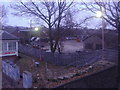
- Clicking on the map will re-center to the selected point.
- The higher the marker number, the further away the image location is from the centre of the postcode.
Image Listing (106 Images Found)
Images are licensed for reuse under creativecommons.org/licenses/by-sa/2.0
Image
Details
Distance
1
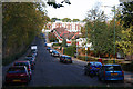
Park Side
This road runs down from Dollis Hill Lane beside Gladstone Park to come to an abrupt halt just short of the railway line at the bottom of the hill, close to Dudding Hill Junction.
Image: © Martin Addison
Taken: 23 Oct 2009
0.04 miles
2
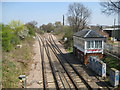
Cricklewood: Dudding Hill Junction and signalbox
This is the Dudding Hill freight-only line that links Cricklewood and Acton. It was built in 1868 as the Midland and South Western Junction Railway, but was rapidly absorbed into the Midland Railway. Passenger services were short-lived, terminating as long ago as 1902.
This is the junction where the eastbound tracks diverge, with the line to Hendon and the north going left, and the line to Cricklewood and the south going right. In fact the two separate tracks parallel one another for some distance from this junction only finally parting company in Image where the junction is shown on the Ordnance Survey 1:50,000 scale mapping.
According to the current Wikipedia article on the line http://en.wikipedia.org/wiki/Dudding_Hill_Line the signal box and two others like it on the route are fully staffed 24 hours a day, but are threatened with closure with all operations passing to a control room in Upminster.
Image is visible to the right of the tracks.
Image: © Nigel Cox
Taken: 18 Apr 2010
0.05 miles
3
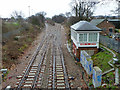
Dudding Hill Junction and signal box
One corner of the triangular junction the normally freight-only Dudding Hill line makes with the Midland main line.
Image: © Robin Webster
Taken: 26 Feb 2011
0.06 miles
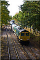
4
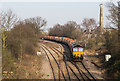
Sand Empties
DB Schenker class 66 66142 heads the 7063 from Tarmac's Churchyard Sidings, near St. Pancras, on its way to Hither Green yard and ultimately Angerstein Wharf. Here it is seen at Dudding Hill Junction having left the St Pancras mainline at Cricklewood Curve Junction which is behind the trees in the centre of the photo. The tracks on the left lead to Brent Curve Junction for trains joining the Midland mainline in a northbound direction.
The Chimney and buildings on the right are Cricklewood Pumping Station - see Image The station forms a key part of the Metropolitan Water Board's north London network of supply.
Image: © Martin Addison
Taken: 12 Mar 2014
0.06 miles
5
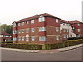
Flats in Campbell Gordon Way, Dollis Hill
These are just by Gladstone Park, on the Southern slopes of Dollis Hill.
Image: © David Hawgood
Taken: 5 Oct 2005
0.06 miles
6
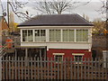
Dudding Hill signal box in Gladstone Park
The line was only used for passengers for a very short time between in 1875 and 1902, and then handed over for goods use only.
Image: © David Howard
Taken: 5 Dec 2007
0.06 miles
7
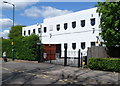
Dollis Hill Synagogue, London NW2
The Ashkenazi Orthodox synagogue is located on the east side of Park Side, near Gladstone Park.
Built in 1937, consecrated in 1938. Since the mid 1990s, the synagogue building has been used a school. The congregation now use a small adjacent hall.
On the gates are three white depictions of a menorah, the candelabrum used in Jewish religious ceremony.
Image: © Jaggery
Taken: 12 May 2012
0.07 miles
8
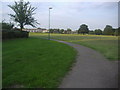
Playing field on Gladstone Park
This area is tucked in the corner of the park and accessed by a path which looks as if it is going to the housing estate on the left but opens up into this field.
Image: © David Howard
Taken: 28 Aug 2013
0.07 miles
9
Council yard by the railway in Gladstone Park
The Dudding Hill line was closed to passengers in 1902 but has continued for goods to the present day.
Image: © David Howard
Taken: 8 Jan 2013
0.07 miles
10
The Dudding Hill Line
66618 brings a train of Lafarge cement tanks through Gladstone Park. Currently only around a dozen trains use this line during weekdays, so trying to photograph one is a case of waiting more in hope than expectation. Just visible behind the train is a semaphore signal - these are still used on the line between here and Acton. It is rumoured that they will be replaced by coloured lights during Christmas 2010.
Behind the bridge on which I am standing is Dudding Hill Junction - see Image by David Hawgood - at which the train will take the left hand route to join the St.Pancras to Leicester mainline in a northbound direction.
Image: © Martin Addison
Taken: 23 Oct 2009
0.07 miles