IMAGES TAKEN NEAR TO
Park Side, LONDON, NW2 6RJ
Introduction
This page details the photographs taken nearby to Park Side, NW2 6RJ by members of the Geograph project.
The Geograph project started in 2005 with the aim of publishing, organising and preserving representative images for every square kilometre of Great Britain, Ireland and the Isle of Man.

There are currently over 7.5m images from over14,400 individuals and you can help contribute to the project by visiting https://www.geograph.org.uk
Image Map
Images are licensed for reuse under creativecommons.org/licenses/by-sa/2.0
Notes
- Clicking on the map will re-center to the selected point.
- The higher the marker number, the further away the image location is from the centre of the postcode.
Image Listing (88 Images Found)
Images are licensed for reuse under creativecommons.org/licenses/by-sa/2.0
Image
Details
Distance
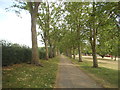
3
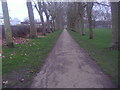
Path through Gladstone Park, Dollis Hill
Image: © David Howard
Taken: 8 Jan 2013
0.04 miles
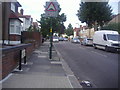
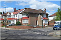
6
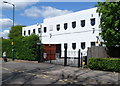
Dollis Hill Synagogue, London NW2
The Ashkenazi Orthodox synagogue is located on the east side of Park Side, near Gladstone Park.
Built in 1937, consecrated in 1938. Since the mid 1990s, the synagogue building has been used a school. The congregation now use a small adjacent hall.
On the gates are three white depictions of a menorah, the candelabrum used in Jewish religious ceremony.
Image: © Jaggery
Taken: 12 May 2012
0.05 miles
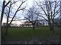
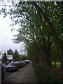
9
Corner of Park Side and Gladstone Park Gardens, London NW2
Viewed across Park Side, Dollis Hill, at the edge of Gladstone Park.
Image: © Jaggery
Taken: 12 May 2012
0.06 miles
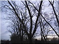
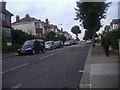
10
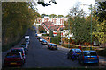
Park Side
This road runs down from Dollis Hill Lane beside Gladstone Park to come to an abrupt halt just short of the railway line at the bottom of the hill, close to Dudding Hill Junction.
Image: © Martin Addison
Taken: 23 Oct 2009
0.07 miles