IMAGES TAKEN NEAR TO
Broadfield Close, LONDON, NW2 6NR
Introduction
This page details the photographs taken nearby to Broadfield Close, NW2 6NR by members of the Geograph project.
The Geograph project started in 2005 with the aim of publishing, organising and preserving representative images for every square kilometre of Great Britain, Ireland and the Isle of Man.

There are currently over 7.5m images from over14,400 individuals and you can help contribute to the project by visiting https://www.geograph.org.uk
Image Map
Images are licensed for reuse under creativecommons.org/licenses/by-sa/2.0
Notes
- Clicking on the map will re-center to the selected point.
- The higher the marker number, the further away the image location is from the centre of the postcode.
Image Listing (75 Images Found)
Images are licensed for reuse under creativecommons.org/licenses/by-sa/2.0
Image
Details
Distance
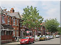
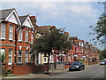
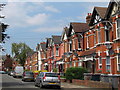
1
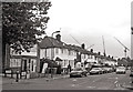
Coppermead Close, Dollis Hill
These post-war houses are between Cricklewood and the top of Dollis Hill. Photo taken from the junction with Mount Road.
Image: © David Hawgood
Taken: 5 Oct 2005
0.07 miles
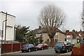
4
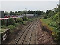
Railway lines west of Edgware Road, NW2
Image: © Mike Quinn
Taken: 2 Aug 2011
0.13 miles
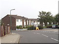
9
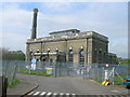
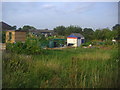
Cricklewood Water Pumping Station off St Michael's Road, London NW2
Image: © Robin Sones
Taken: 24 Apr 2007
0.16 miles