IMAGES TAKEN NEAR TO
Coles Green Road, LONDON, NW2 6ED
Introduction
This page details the photographs taken nearby to Coles Green Road, NW2 6ED by members of the Geograph project.
The Geograph project started in 2005 with the aim of publishing, organising and preserving representative images for every square kilometre of Great Britain, Ireland and the Isle of Man.

There are currently over 7.5m images from over14,400 individuals and you can help contribute to the project by visiting https://www.geograph.org.uk
Image Map
Images are licensed for reuse under creativecommons.org/licenses/by-sa/2.0
Notes
- Clicking on the map will re-center to the selected point.
- The higher the marker number, the further away the image location is from the centre of the postcode.
Image Listing (28 Images Found)
Images are licensed for reuse under creativecommons.org/licenses/by-sa/2.0
Image
Details
Distance
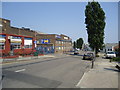
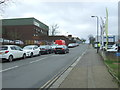
1
Coles Green Road
Coles Green Road at roundabout with Dollis Hill Lane
Image: © Shaun Ferguson
Taken: 1 Apr 2009
0.09 miles
2
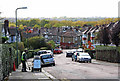
The Crescent
The road sweeper goes about his duties on this street with an excellent view over Gladstone Park to Dudden Hill and Willesden.
Image: © Martin Addison
Taken: 23 Oct 2009
0.15 miles
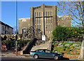
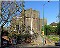
3
Maharashtra Mandal London
A centre for Marathi folk in London.
Image: © Robin Webster
Taken: 26 Feb 2011
0.15 miles
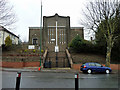
5
St Paul, Dollis Hill Lane, London NW2 - Foundation stone
Image: © John Salmon
Taken: 13 Nov 2004
0.16 miles
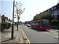
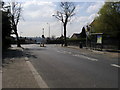
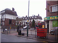
8
Humber Road, London NW2
Looking south west from Edgware Road (A5).
Image: © JThomas
Taken: 18 Mar 2017
0.18 miles
9
Junction of Coles Green Road and Oxgate Lane
Image: © David Howard
Taken: 11 Feb 2011
0.19 miles