IMAGES TAKEN NEAR TO
St. Pauls Avenue, LONDON, NW2 5TG
Introduction
This page details the photographs taken nearby to St. Pauls Avenue, NW2 5TG by members of the Geograph project.
The Geograph project started in 2005 with the aim of publishing, organising and preserving representative images for every square kilometre of Great Britain, Ireland and the Isle of Man.

There are currently over 7.5m images from over14,400 individuals and you can help contribute to the project by visiting https://www.geograph.org.uk
Image Map
Images are licensed for reuse under creativecommons.org/licenses/by-sa/2.0
Notes
- Clicking on the map will re-center to the selected point.
- The higher the marker number, the further away the image location is from the centre of the postcode.
Image Listing (198 Images Found)
Images are licensed for reuse under creativecommons.org/licenses/by-sa/2.0
Image
Details
Distance
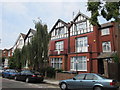
1
St. Paul's Avenue / Grove Road, NW2
Shows the location of Image
Image: © Mike Quinn
Taken: 2 Aug 2011
0.02 miles
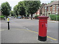
3
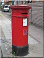
"Anonymous" (Victorian) postbox, St. Paul's Avenue / Grove Road, NW2
The low posting aperture dates this postbox to 1883-87. The location of this postbox is shown in Image, Image and Image
Image: © Mike Quinn
Taken: 2 Aug 2011
0.04 miles
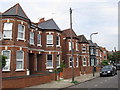
4
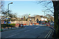
Junction of St Pauls Avenue and Park Avenue, NW10
Image: © Robin Webster
Taken: 19 Mar 2011
0.05 miles
5
St. Paul's Avenue / Grove Road, NW2 (2)
Shows the location of Image
Image: © Mike Quinn
Taken: 2 Aug 2011
0.05 miles
6
St. Paul's Avenue, NW2
East of Grove Road; shows the location of Image
Image: © Mike Quinn
Taken: 2 Aug 2011
0.05 miles
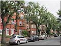
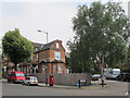
7
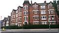
Avenue Mansions
The date 1896 is inscribed at the top of the central tower feature.
Image: © David Martin
Taken: 16 Oct 2015
0.06 miles
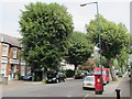
8
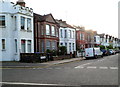
Riffel Road, London NW2
A view from the corner of Cranhurst Road looking NW towards the Jeymer Avenue junction.
The Castle http://www.geograph.org.uk/photo/2973199 is on the left.
Image: © Jaggery
Taken: 12 May 2012
0.07 miles