IMAGES TAKEN NEAR TO
St. Pauls Avenue, LONDON, NW2 5SX
Introduction
This page details the photographs taken nearby to St. Pauls Avenue, NW2 5SX by members of the Geograph project.
The Geograph project started in 2005 with the aim of publishing, organising and preserving representative images for every square kilometre of Great Britain, Ireland and the Isle of Man.

There are currently over 7.5m images from over14,400 individuals and you can help contribute to the project by visiting https://www.geograph.org.uk
Image Map
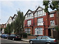
Images are licensed for reuse under creativecommons.org/licenses/by-sa/2.0
Notes
- Clicking on the map will re-center to the selected point.
- The higher the marker number, the further away the image location is from the centre of the postcode.
Image Listing (220 Images Found)
Images are licensed for reuse under creativecommons.org/licenses/by-sa/2.0
Image
Details
Distance
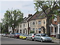
2
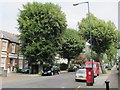
St. Paul's Avenue, NW2
East of Grove Road; shows the location of Image
Image: © Mike Quinn
Taken: 2 Aug 2011
0.03 miles
3
St. Paul's Avenue / Grove Road, NW2 (2)
Shows the location of Image
Image: © Mike Quinn
Taken: 2 Aug 2011
0.03 miles
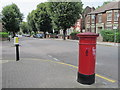
4
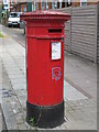
"Anonymous" (Victorian) postbox, St. Paul's Avenue / Grove Road, NW2
The low posting aperture dates this postbox to 1883-87. The location of this postbox is shown in Image, Image and Image
Image: © Mike Quinn
Taken: 2 Aug 2011
0.04 miles
5
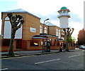
Central Mosque Of Brent, Willesden Green London NW2
Located on the south side of Station Parade and Lennon Road in a converted former church.
The mosque accommodates 900 worshippers.
Image: © Jaggery
Taken: 12 May 2012
0.04 miles
6
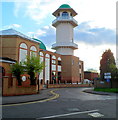
Minaret, Central Mosque Of Brent, Willesden Green London NW2
Viewed along Lennon Road from Station Parade. The mosque http://www.geograph.org.uk/photo/2973181 is a converted former church.
Image: © Jaggery
Taken: 12 May 2012
0.04 miles
7
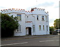
The Castle, London NW2
The crenellated house, address 1 Riffel Road, has its front door on Cranhurst Road, near the Lennon Road junction.
Image: © Jaggery
Taken: 12 May 2012
0.04 miles
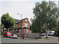
10
St. Paul's Avenue / Grove Road, NW2
Shows the location of Image
Image: © Mike Quinn
Taken: 2 Aug 2011
0.06 miles