IMAGES TAKEN NEAR TO
Willesden Lane, LONDON, NW2 5RZ
Introduction
This page details the photographs taken nearby to Willesden Lane, NW2 5RZ by members of the Geograph project.
The Geograph project started in 2005 with the aim of publishing, organising and preserving representative images for every square kilometre of Great Britain, Ireland and the Isle of Man.

There are currently over 7.5m images from over14,400 individuals and you can help contribute to the project by visiting https://www.geograph.org.uk
Image Map
Images are licensed for reuse under creativecommons.org/licenses/by-sa/2.0
Notes
- Clicking on the map will re-center to the selected point.
- The higher the marker number, the further away the image location is from the centre of the postcode.
Image Listing (155 Images Found)
Images are licensed for reuse under creativecommons.org/licenses/by-sa/2.0
Image
Details
Distance
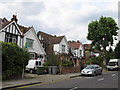
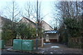
1
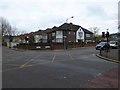
Chambers Lane, Willesden
View from the top of All Souls Avenue
Image: © David Hawgood
Taken: 28 Jun 2005
0.05 miles
2
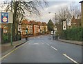
Sidmouth Road, approaching the junction with Willesden Lane
Beyond Willesden Lane the road continues as Lydford Road.
Image: © Stefan Czapski
Taken: 25 Dec 2012
0.05 miles
3
Houses on Sidmouth Road, Willesden Green
Image: © David Howard
Taken: 25 Jan 2021
0.05 miles
5
Sidmouth Road, Willesden Green
By the Willesden Lane crossroads
Image: © David Howard
Taken: 25 Jan 2021
0.07 miles
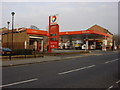
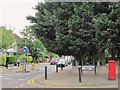
6
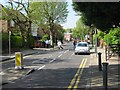
Lydford Road, looking southwest, NW2
Residential road in Willesden Green.
Image
Image: © L S Wilson
Taken: 15 May 2010
0.08 miles
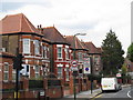
7
Corner of Brondesbury Park/Sidmouth Road with Cambodian Embassy
Image: © David Smith
Taken: 26 Nov 2015
0.09 miles
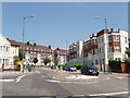
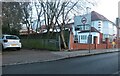
8
Lydford Road / Chatsworth Road, NW2
Shows the location of Image
Image: © Mike Quinn
Taken: 2 Aug 2011
0.09 miles