IMAGES TAKEN NEAR TO
Villiers Road, LONDON, NW2 5PU
Introduction
This page details the photographs taken nearby to Villiers Road, NW2 5PU by members of the Geograph project.
The Geograph project started in 2005 with the aim of publishing, organising and preserving representative images for every square kilometre of Great Britain, Ireland and the Isle of Man.

There are currently over 7.5m images from over14,400 individuals and you can help contribute to the project by visiting https://www.geograph.org.uk
Image Map
Images are licensed for reuse under creativecommons.org/licenses/by-sa/2.0
Notes
- Clicking on the map will re-center to the selected point.
- The higher the marker number, the further away the image location is from the centre of the postcode.
Image Listing (168 Images Found)
Images are licensed for reuse under creativecommons.org/licenses/by-sa/2.0
Image
Details
Distance
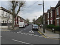
2
Villiers Road / Belton Road, NW2 (2)
Shows the location of Image
Image: © Mike Quinn
Taken: 2 Aug 2011
0.05 miles
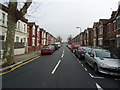
7
Willesden - Dudden Hill Lane at Colin Road
Image: © Peter Whatley
Taken: 11 Apr 2011
0.07 miles
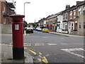
9
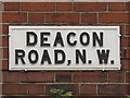
Sign for Deacon Road, NW2
Image: © Mike Quinn
Taken: 2 Aug 2011
0.09 miles
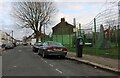
10
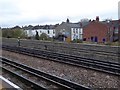
Houses that back onto the rail tracks at Dollis Hill
Houses in Chapter Road, on the south of the tube station
Image: © David Smith
Taken: 26 Nov 2015
0.09 miles