IMAGES TAKEN NEAR TO
Park Avenue, LONDON, NW2 5AW
Introduction
This page details the photographs taken nearby to Park Avenue, NW2 5AW by members of the Geograph project.
The Geograph project started in 2005 with the aim of publishing, organising and preserving representative images for every square kilometre of Great Britain, Ireland and the Isle of Man.

There are currently over 7.5m images from over14,400 individuals and you can help contribute to the project by visiting https://www.geograph.org.uk
Image Map
Images are licensed for reuse under creativecommons.org/licenses/by-sa/2.0
Notes
- Clicking on the map will re-center to the selected point.
- The higher the marker number, the further away the image location is from the centre of the postcode.
Image Listing (240 Images Found)
Images are licensed for reuse under creativecommons.org/licenses/by-sa/2.0
Image
Details
Distance
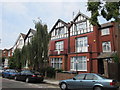
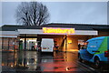
4
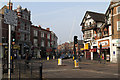
High Road, Willesden
Seen from the junction with Walm Lane and Willesden Lane.
Image: © Martin Addison
Taken: 1 Mar 2012
0.03 miles
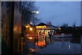
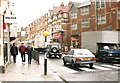
9
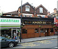
Angie's III, Willesden Green, London NW2
Pub in Walm Lane. A walking companion said that Angie's I and Angie's II are also in London, but did not elaborate.
Image: © Jaggery
Taken: 12 May 2012
0.06 miles