IMAGES TAKEN NEAR TO
Petrie Close, Exeter Road, LONDON, NW2 4SS
Introduction
This page details the photographs taken nearby to Petrie Close, Exeter Road, NW2 4SS by members of the Geograph project.
The Geograph project started in 2005 with the aim of publishing, organising and preserving representative images for every square kilometre of Great Britain, Ireland and the Isle of Man.

There are currently over 7.5m images from over14,400 individuals and you can help contribute to the project by visiting https://www.geograph.org.uk
Image Map
Images are licensed for reuse under creativecommons.org/licenses/by-sa/2.0
Notes
- Clicking on the map will re-center to the selected point.
- The higher the marker number, the further away the image location is from the centre of the postcode.
Image Listing (183 Images Found)
Images are licensed for reuse under creativecommons.org/licenses/by-sa/2.0
Image
Details
Distance
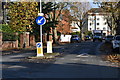
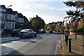
4
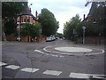
Mini roundabout at the junction of Exeter Road and Mapesbury Road
Image: © David Howard
Taken: 3 Oct 2013
0.04 miles
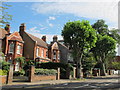
8
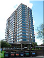
Windmill Court, London NW2
Completed in 1967, Windmill Court is a high-rise block of flats on the corner
of Mapesbury Road and Shoot-up Hill. Its height is 46.6 metres (153 feet).
Variously-labelled recycling bins line the wall on the Shoot-up Hill side of the building.
Image: © Jaggery
Taken: 12 May 2012
0.05 miles