IMAGES TAKEN NEAR TO
Dawlish Road, LONDON, NW2 4EY
Introduction
This page details the photographs taken nearby to Dawlish Road, NW2 4EY by members of the Geograph project.
The Geograph project started in 2005 with the aim of publishing, organising and preserving representative images for every square kilometre of Great Britain, Ireland and the Isle of Man.

There are currently over 7.5m images from over14,400 individuals and you can help contribute to the project by visiting https://www.geograph.org.uk
Image Map
Images are licensed for reuse under creativecommons.org/licenses/by-sa/2.0
Notes
- Clicking on the map will re-center to the selected point.
- The higher the marker number, the further away the image location is from the centre of the postcode.
Image Listing (116 Images Found)
Images are licensed for reuse under creativecommons.org/licenses/by-sa/2.0
Image
Details
Distance
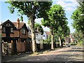
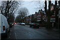
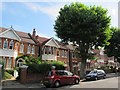
2

Brondesbury: Dartmouth Road, NW2
The council's tree-lopping crews have been busy at work down Dartmouth Road, as viewed from the Lydford Road junction.
Image: © Nigel Cox
Taken: 18 Apr 2010
0.06 miles
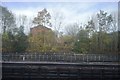
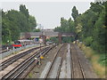
5

Brondesbury: Railway lines east of Willesden Green station
A southbound Jubilee line train trundles under the Lydford Road bridge here heading for Kilburn station. There are six tracks here, in use from left to right as Metropolitan Line up, Jubilee Line up (where the train is running,), Jubilee down, Metropolitan down, and Chiltern Railways (without the electrified central rail), up and down.
Image: © Nigel Cox
Taken: 18 Apr 2010
0.09 miles
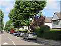
7
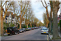
Dartmouth Road
Lined with London plane trees.
Image: © Stephen Richards
Taken: 15 Apr 2011
0.10 miles
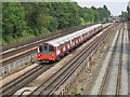
9
Railway and underground lines west of Mapesbury Road, NW2
Image: © Mike Quinn
Taken: 2 Aug 2011
0.11 miles
10
Railway and underground lines east of Lydford Road, NW2
Image: © Mike Quinn
Taken: 2 Aug 2011
0.12 miles