IMAGES TAKEN NEAR TO
Dartmouth Road, LONDON, NW2 4EP
Introduction
This page details the photographs taken nearby to Dartmouth Road, NW2 4EP by members of the Geograph project.
The Geograph project started in 2005 with the aim of publishing, organising and preserving representative images for every square kilometre of Great Britain, Ireland and the Isle of Man.

There are currently over 7.5m images from over14,400 individuals and you can help contribute to the project by visiting https://www.geograph.org.uk
Image Map
Images are licensed for reuse under creativecommons.org/licenses/by-sa/2.0
Notes
- Clicking on the map will re-center to the selected point.
- The higher the marker number, the further away the image location is from the centre of the postcode.
Image Listing (90 Images Found)
Images are licensed for reuse under creativecommons.org/licenses/by-sa/2.0
Image
Details
Distance
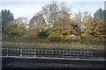
1
Railway and underground lines west of Mapesbury Road, NW2 (2)
This is a "reverse" view to that in Image
Image: © Mike Quinn
Taken: 2 Aug 2011
0.04 miles
3
Railway and underground lines west of Mapesbury Road, NW2
Image: © Mike Quinn
Taken: 2 Aug 2011
0.06 miles
4
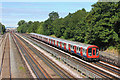
Metropolitan Line
Underground train near Kilburn.
Image: © Wayland Smith
Taken: 9 Aug 2015
0.07 miles
5
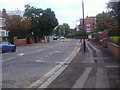
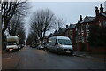
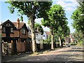
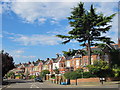
Mapesbury Road, Brondesbury
Looking towards the junction with Dartmouth Road
Image: © David Howard
Taken: 3 Oct 2013
0.08 miles
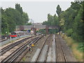
6
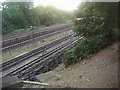
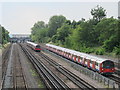
Railway lines by Mapesbury Road
Main line, Metropolitan Line and Jubilee Line from left to right.
Image: © David Howard
Taken: 3 Oct 2013
0.08 miles
7
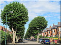
Mapesbury Road, NW2 (2)
South of its junction with Teignmouth Road.
Image: © Mike Quinn
Taken: 2 Aug 2011
0.08 miles