IMAGES TAKEN NEAR TO
Imperial Close, LONDON, NW2 4AF
Introduction
This page details the photographs taken nearby to Imperial Close, NW2 4AF by members of the Geograph project.
The Geograph project started in 2005 with the aim of publishing, organising and preserving representative images for every square kilometre of Great Britain, Ireland and the Isle of Man.

There are currently over 7.5m images from over14,400 individuals and you can help contribute to the project by visiting https://www.geograph.org.uk
Image Map
Images are licensed for reuse under creativecommons.org/licenses/by-sa/2.0
Notes
- Clicking on the map will re-center to the selected point.
- The higher the marker number, the further away the image location is from the centre of the postcode.
Image Listing (73 Images Found)
Images are licensed for reuse under creativecommons.org/licenses/by-sa/2.0
Image
Details
Distance
2
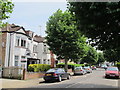
Anson Road (near Oman Avenue), NW2
Shows the location of Image
Image: © Mike Quinn
Taken: 2 Aug 2011
0.04 miles
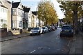
3
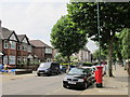
Anson Road (near Oman Avenue), NW2 (2)
Shows the location of Image
Image: © Mike Quinn
Taken: 2 Aug 2011
0.04 miles
4
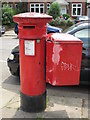
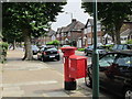
"Anonymous" (Victorian) postbox, Anson Road (near Oman Avenue), NW2
The high posting aperture dates this postbox to 1879-83. The location of this postbox is shown in Image and Image
Image: © Mike Quinn
Taken: 2 Aug 2011
0.04 miles
5
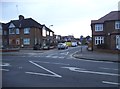
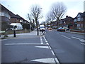
Tracey Avenue at the junction of Anson Road
Image: © David Howard
Taken: 14 Jan 2015
0.04 miles
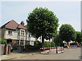
8
Melrose Avenue, NW2 (4)
Shows the location of Image
Image: © Mike Quinn
Taken: 2 Aug 2011
0.06 miles
9
Anson Road at the junction of Oman Avenue
Image: © David Howard
Taken: 14 Jan 2015
0.06 miles
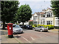
10
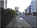
Melrose Avenue, Dudden Hill
The flats on the right have only gone up recently.
Image: © David Howard
Taken: 14 Jan 2015
0.06 miles