IMAGES TAKEN NEAR TO
Garlinge Road, LONDON, NW2 3TR
Introduction
This page details the photographs taken nearby to Garlinge Road, NW2 3TR by members of the Geograph project.
The Geograph project started in 2005 with the aim of publishing, organising and preserving representative images for every square kilometre of Great Britain, Ireland and the Isle of Man.

There are currently over 7.5m images from over14,400 individuals and you can help contribute to the project by visiting https://www.geograph.org.uk
Image Map
Images are licensed for reuse under creativecommons.org/licenses/by-sa/2.0
Notes
- Clicking on the map will re-center to the selected point.
- The higher the marker number, the further away the image location is from the centre of the postcode.
Image Listing (244 Images Found)
Images are licensed for reuse under creativecommons.org/licenses/by-sa/2.0
Image
Details
Distance

4
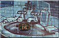
MR16
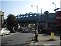
Still surviving despite the modern mural painted on the abutment of the bridge is this Metropolitan Railway plate carrying the structure number.
Image: © Martin Addison
Taken: 11 Mar 2011
0.04 miles
5
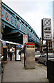
Metropolitan Railway Bridge
The massive structure carrying the Metropolitan and Jubilee Lines over the A5 at the point where Kilburn High Road becomes Shoot-Up Hill. Beneath, on the right of the photo is the entrance to Kilburn Station. This view is from Maygrove Road and a significant amount of street furniture is apparent in the foreground.
Image: © Martin Addison
Taken: 11 Mar 2011
0.04 miles
6
Shoot Up Hill NW2
At the junction with Exeter Road
Image: © Robin Sones
Taken: 8 Oct 2010
0.04 miles
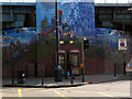
7
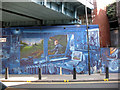
Kilburn High Road mural, NW6
One of a number of murals under railway lines in the Kilburn area.
Image: © Phillip Perry
Taken: 22 Apr 2007
0.05 miles
8
Brondesbury: Iverson Road
Looking east
Image: © Dr Neil Clifton
Taken: 25 Nov 2015
0.05 miles
10
Kilburn High Road mural II, NW6
On the corner of Kilburn High Road and Christchurch Avenue, NW6.
It would've been a lot better to view if it were not for all the street furniture.
Image: © Phillip Perry
Taken: 15 Apr 2007
0.05 miles