IMAGES TAKEN NEAR TO
Shoot Up Hill, LONDON, NW2 3TD
Introduction
This page details the photographs taken nearby to Shoot Up Hill, NW2 3TD by members of the Geograph project.
The Geograph project started in 2005 with the aim of publishing, organising and preserving representative images for every square kilometre of Great Britain, Ireland and the Isle of Man.

There are currently over 7.5m images from over14,400 individuals and you can help contribute to the project by visiting https://www.geograph.org.uk
Image Map
Images are licensed for reuse under creativecommons.org/licenses/by-sa/2.0
Notes
- Clicking on the map will re-center to the selected point.
- The higher the marker number, the further away the image location is from the centre of the postcode.
Image Listing (220 Images Found)
Images are licensed for reuse under creativecommons.org/licenses/by-sa/2.0
Image
Details
Distance
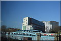
1
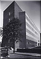
"Telephone House" in 1954
This photo of the old Headquarters of the GPO Telecommunications London North West Area was taken shortly after it had been opened. It is situated at the junction of Shoot-Up-Hill and Exeter Road
Image: © Anthony Harrison
Taken: Unknown
0.04 miles
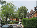
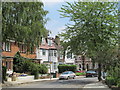
3

Fordwych Road London NW2
A view NW from near the corner of St Cuthberts Road.
Image: © Jaggery
Taken: 12 May 2012
0.06 miles
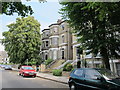
5
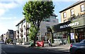
Shoot Up Hill NW2
At the junction with Exeter Road
Image: © Robin Sones
Taken: 8 Oct 2010
0.07 miles
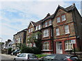
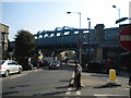
7

Corner of Kingscroft Road and St Cuthberts Road, London NW2
Kingscroft Road is on the left, St Cuthberts Road is on the right.
Image: © Jaggery
Taken: 12 May 2012
0.08 miles