IMAGES TAKEN NEAR TO
Fordwych Road, LONDON, NW2 3NN
Introduction
This page details the photographs taken nearby to Fordwych Road, NW2 3NN by members of the Geograph project.
The Geograph project started in 2005 with the aim of publishing, organising and preserving representative images for every square kilometre of Great Britain, Ireland and the Isle of Man.

There are currently over 7.5m images from over14,400 individuals and you can help contribute to the project by visiting https://www.geograph.org.uk
Image Map
Images are licensed for reuse under creativecommons.org/licenses/by-sa/2.0
Notes
- Clicking on the map will re-center to the selected point.
- The higher the marker number, the further away the image location is from the centre of the postcode.
Image Listing (137 Images Found)
Images are licensed for reuse under creativecommons.org/licenses/by-sa/2.0
Image
Details
Distance
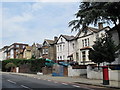
7
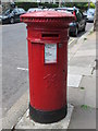
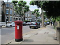
Victorian postbox, Fordwych Road, NW2
Image: © Mike Quinn
Taken: 5 Jul 2011
0.08 miles
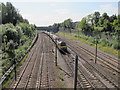
9

London Borough of Camden : Railway Track
Heading underneath the bridge.
Image: © Lewis Clarke
Taken: 4 Oct 2018
0.08 miles
10
Shoot-up Hill, NW2 (2)
North of Kingscroft Road; shows the location of Image
Image: © Mike Quinn
Taken: 5 Jul 2011
0.08 miles