IMAGES TAKEN NEAR TO
Fordwych Road, LONDON, NW2 3LY
Introduction
This page details the photographs taken nearby to Fordwych Road, NW2 3LY by members of the Geograph project.
The Geograph project started in 2005 with the aim of publishing, organising and preserving representative images for every square kilometre of Great Britain, Ireland and the Isle of Man.

There are currently over 7.5m images from over14,400 individuals and you can help contribute to the project by visiting https://www.geograph.org.uk
Image Map
Images are licensed for reuse under creativecommons.org/licenses/by-sa/2.0
Notes
- Clicking on the map will re-center to the selected point.
- The higher the marker number, the further away the image location is from the centre of the postcode.
Image Listing (132 Images Found)
Images are licensed for reuse under creativecommons.org/licenses/by-sa/2.0
Image
Details
Distance
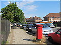
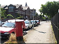
4
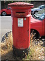
Edward VII postbox, Lichfield Road / Horton Avenue, NW2
Image: © Mike Quinn
Taken: 2 Aug 2011
0.09 miles
5
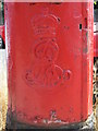
Edward VII postbox, Lichfield Road / Horton Avenue, NW2 - royal cipher
See Image
Image: © Mike Quinn
Taken: 2 Aug 2011
0.09 miles
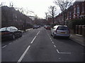
6
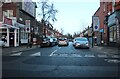
Richborough Road from Cricklewood Broadway
Image: © David Howard
Taken: 25 Jan 2021
0.10 miles
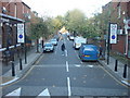
7
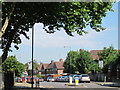
Westbere Road / Lichfield Road, NW2
Shows the location of Image
Image: © Mike Quinn
Taken: 2 Aug 2011
0.11 miles
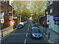
8
Lichfield Road / Westbere Road, NW2
Shows the location of Image
Image: © Mike Quinn
Taken: 2 Aug 2011
0.11 miles
9
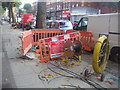
Hole in the road, Cricklewood Broadway
Virgin Media were sorting out the cables.
Image: © David Howard
Taken: 3 Oct 2013
0.11 miles