IMAGES TAKEN NEAR TO
Chichele Road, LONDON, NW2 3DD
Introduction
This page details the photographs taken nearby to Chichele Road, NW2 3DD by members of the Geograph project.
The Geograph project started in 2005 with the aim of publishing, organising and preserving representative images for every square kilometre of Great Britain, Ireland and the Isle of Man.

There are currently over 7.5m images from over14,400 individuals and you can help contribute to the project by visiting https://www.geograph.org.uk
Image Map
Images are licensed for reuse under creativecommons.org/licenses/by-sa/2.0
Notes
- Clicking on the map will re-center to the selected point.
- The higher the marker number, the further away the image location is from the centre of the postcode.
Image Listing (159 Images Found)
Images are licensed for reuse under creativecommons.org/licenses/by-sa/2.0
Image
Details
Distance
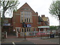
1
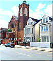
Brent Mosque and Islamic Centre, Chichele Road, London NW2
This is the Chichele Road side of the building.
The main entrance is from the opposite side, in Howard Road.
The mosque has a capacity of 2,300 worshippers.
Image: © Jaggery
Taken: 12 May 2012
0.02 miles
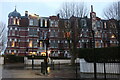
2
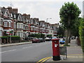
Chichele Road / Rockhall Road, NW2
Shows the location of Image
Image: © Mike Quinn
Taken: 2 Aug 2011
0.02 miles
4
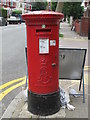
Edward VII postbox, Chichele Road / Rockhall Road, NW2
Image: © Mike Quinn
Taken: 2 Aug 2011
0.04 miles
5
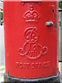
Edward VII postbox, Chichele Road / Rockhall Road, NW2 - royal cipher
See Image
Image: © Mike Quinn
Taken: 2 Aug 2011
0.04 miles
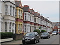
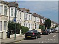
6
Argyle Mansions, Chichele Road / Rockhall Road, NW2 (2)
Shows the location of Image
Image: © Mike Quinn
Taken: 2 Aug 2011
0.04 miles
7
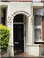
Entrance to Argyle Mansions, Chichele Road / Rockhall Road, NW2 (2)
See Image
Image: © Mike Quinn
Taken: 2 Aug 2011
0.04 miles
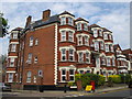
9
Chichele Mansions, Cricklewood
NW2 and NW10 have many suburbs within them, and there is now no exact known boundary where Cricklewood and Willesden Green begin (as both are in NW2), but the Walm Lane/Chichele Road boundary appears to indicate the original official line. My mother was born and lived around the corner from 1933-47.
Image: © David Howard
Taken: 5 Jan 2021
0.05 miles
10
Dar al-Islam Foundation, Anson Road at the Junction with Chichele Road, London NW2
Image: © Robin Sones
Taken: 24 Apr 2007
0.06 miles