IMAGES TAKEN NEAR TO
Burgess Hill, LONDON, NW2 2BY
Introduction
This page details the photographs taken nearby to Burgess Hill, NW2 2BY by members of the Geograph project.
The Geograph project started in 2005 with the aim of publishing, organising and preserving representative images for every square kilometre of Great Britain, Ireland and the Isle of Man.

There are currently over 7.5m images from over14,400 individuals and you can help contribute to the project by visiting https://www.geograph.org.uk
Image Map
Images are licensed for reuse under creativecommons.org/licenses/by-sa/2.0
Notes
- Clicking on the map will re-center to the selected point.
- The higher the marker number, the further away the image location is from the centre of the postcode.
Image Listing (187 Images Found)
Images are licensed for reuse under creativecommons.org/licenses/by-sa/2.0
Image
Details
Distance
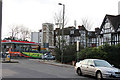
2
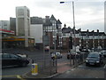
Tower Garage on Finchley Road, Childs Hill
Image: © David Howard
Taken: 3 Jan 2008
0.05 miles
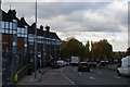
5
Vernon Court, Hendon Way
Housing development running down beyond the Art Deco garage clock tower.
Image: © Colin Pyle
Taken: 20 Oct 2009
0.06 miles
6
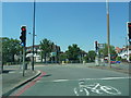
Junction of Hendon Way and Finchley Road, Hampstead
Image: © Alexander P Kapp
Taken: 24 Jul 2012
0.06 miles
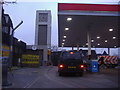
8
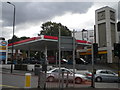
Esso Petrol Station and clock tower, Finchley Road NW2
At the junction with Hendon Way
Image: © Robin Sones
Taken: 25 Sep 2010
0.07 miles
9
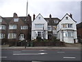
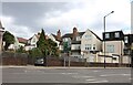
Houses on Finchley Road, Hampstead
This is the furthest NW corner of Hampstead, bordering on West Hampstead and Cricklewood
Image: © David Howard
Taken: 28 Mar 2015
0.07 miles
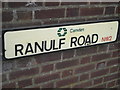
10
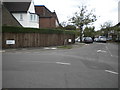
Ardwick Road NW2
At the junction with Ranulf Road
Image: © Robin Sones
Taken: 25 Sep 2010
0.08 miles