IMAGES TAKEN NEAR TO
St. Pauls Mews, LONDON, NW1 9TZ
Introduction
This page details the photographs taken nearby to St. Pauls Mews, NW1 9TZ by members of the Geograph project.
The Geograph project started in 2005 with the aim of publishing, organising and preserving representative images for every square kilometre of Great Britain, Ireland and the Isle of Man.

There are currently over 7.5m images from over14,400 individuals and you can help contribute to the project by visiting https://www.geograph.org.uk
Image Map (Loading...)


Getting Data...Please wait
Leaflet Map data © OpenStreetMap
Images are licensed for reuse under creativecommons.org/licenses/by-sa/2.0
Notes
- Clicking on the map will re-center to the selected point.
- The higher the marker number, the further away the image location is from the centre of the postcode.
Image Listing (58 Images Found)
Images are licensed for reuse under creativecommons.org/licenses/by-sa/2.0
Image
Details
Distance
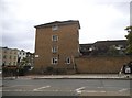
1
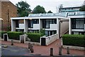
Housing units, Maiden Lane Estate
Maiden Lane Estate is a large early 1980s housing estate to the designs of architects (Gordon Benson and Alan Forsyth) working in the London Borough of Camden Architects Department. Currently undergoing major refurbishment.
Image: © Jim Osley
Taken: 21 Jul 2016
0.07 miles
2
Elm Friars Walk, Maiden Lane Estate
Maiden Lane Estate is a large early 1980s housing estate to the designs of architects (Gordon Benson and Alan Forsyth) working in the London Borough of Camden Architects Department.
Image: © Jim Osley
Taken: 21 Jul 2016
0.07 miles
3
Flats on the corner of York Way and Agar Grove
Image: © David Howard
Taken: 28 Aug 2014
0.08 miles
4
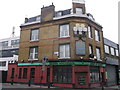
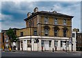
Rosie McCann's Public House, Camden
Public house on the junction of and Brandon Road and York Way (on the right).
I am assuming this is an Irish pub!
Image: © David Anstiss
Taken: 10 Mar 2013
0.08 miles
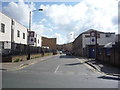
6
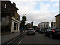
York Way at the junction of Brewery Road
Image: © David Howard
Taken: 29 Aug 2012
0.10 miles

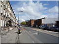
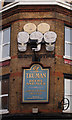
8
Former "Butchers Arms" public house, Brewery Road/York Way
One of number of 19th century public houses built to serve the nearby Metropolitan Cattle Market (later Caledonian Market).
Image: © Jim Osley
Taken: 21 Jul 2016
0.10 miles