IMAGES TAKEN NEAR TO
Royal College Street, LONDON, NW1 9QP
Introduction
This page details the photographs taken nearby to Royal College Street, NW1 9QP by members of the Geograph project.
The Geograph project started in 2005 with the aim of publishing, organising and preserving representative images for every square kilometre of Great Britain, Ireland and the Isle of Man.

There are currently over 7.5m images from over14,400 individuals and you can help contribute to the project by visiting https://www.geograph.org.uk
Image Map (Loading...)


Getting Data...Please wait
Leaflet Map data © OpenStreetMap
Images are licensed for reuse under creativecommons.org/licenses/by-sa/2.0
Notes
- Clicking on the map will re-center to the selected point.
- The higher the marker number, the further away the image location is from the centre of the postcode.
Image Listing (362 Images Found)
Images are licensed for reuse under creativecommons.org/licenses/by-sa/2.0
Image
Details
Distance
1
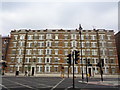
Houses, Royal College Street
At the junction with Kentish Town Road
Image: © Robin Sones
Taken: 18 Apr 2020
0.02 miles
2

View NNW along Camden High Street towards Camden Lock
This view is taken looking north-northwest along Camden High Street towards Camden Lock, as advertised by the vibrant blue railway bridge in the background!
Image: © Robert Lamb
Taken: 13 Feb 2010
0.02 miles
3
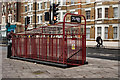
Creation Studios, Kentish Town
Basement public conveniences were once a common feature of inner London, but in recent years they have been closed down by local authorities, only to find new uses, in this case, a music studio. More at this http://www.camdennewjournal.com/studioloos. A mile or so to the north the public convenience have been converted to a cocktail bar.
Image: © Jim Osley
Taken: 9 Dec 2016
0.02 miles
4
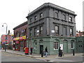
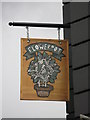
The Flowerpot; and the former South Kentish Town tube station
At the junction of Kentish Town Road and Castle Street, NW1. For info on the former tube station, see http://www.cwgcuser.org.uk/personal/hiddenc/sktts.htm.
Image: © Mike Quinn
Taken: 10 Jun 2009
0.02 miles
5
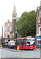
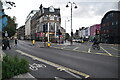
Moving Off
A 214 bus starts away from the lights at the junction of Kentish Town Road and Royal College Street. Behind is the spire of St. Andrew's Greek Orthodox Cathedral. Beyond that is the fancy brickwork of The Abbey Tavern.
Image: © Martin Addison
Taken: 4 Oct 2012
0.02 miles
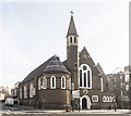
7
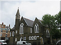
Greek Orthodox Cathedral of St. Andrew
The building is on Kentish Town Road. It was originally an Anglican Church dedicated to St Barnabas.
Image: © Richard Rogerson
Taken: 4 May 2017
0.02 miles
8
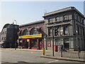
Kentish Town Road, NW1, south of Castle Road
Shows the location of Image (now possibly reverted to being called The Bullet - see http://deadpubs.co.uk/LondonPubs/StPancras/CastleTavern.shtml), Image, and the Kent Café in a hideously out of keeping new building that wasn't there in June 2009 when I took the photo of The Flowerpot pub.
Image: © Mike Quinn
Taken: 8 Mar 2011
0.03 miles
10
St Andrew Greek Orthodox Church, Kentish Town
Image: © John Salmon
Taken: 5 Feb 2020
0.03 miles