IMAGES TAKEN NEAR TO
Harmood Street, LONDON, NW1 8DS
Introduction
This page details the photographs taken nearby to Harmood Street, NW1 8DS by members of the Geograph project.
The Geograph project started in 2005 with the aim of publishing, organising and preserving representative images for every square kilometre of Great Britain, Ireland and the Isle of Man.

There are currently over 7.5m images from over14,400 individuals and you can help contribute to the project by visiting https://www.geograph.org.uk
Image Map
Images are licensed for reuse under creativecommons.org/licenses/by-sa/2.0
Notes
- Clicking on the map will re-center to the selected point.
- The higher the marker number, the further away the image location is from the centre of the postcode.
Image Listing (540 Images Found)
Images are licensed for reuse under creativecommons.org/licenses/by-sa/2.0
Image
Details
Distance
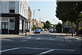
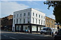
4
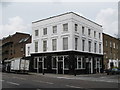
The Prince of Wales, Prince of Wales Road / Harmood Street, NW5
Image: © Mike Quinn
Taken: 10 Jun 2009
0.04 miles
5
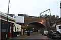
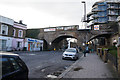
Railway bridge over Castle Road, Kentish Town
Image: © David Howard
Taken: 8 Nov 2020
0.04 miles
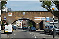
6
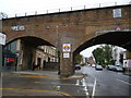
Kentish Town West Rail Bridge, Prince of Wales Road NW5
At the junction with Dalby Street
Image: © Robin Sones
Taken: 23 Sep 2012
0.06 miles
7
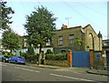
Hammood Street, London NW1
Terrace houses on the east side of Hammood Street. These are some of the original housing from this street.
Image: © Christine Matthews
Taken: 18 Sep 2008
0.06 miles
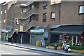
8
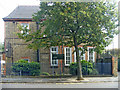
Chalcot School, Harmood Street, London NW1
Chalcot School is on the east side of Harmood Street.
Image: © Christine Matthews
Taken: 18 Sep 2008
0.06 miles