IMAGES TAKEN NEAR TO
Malden Crescent, LONDON, NW1 8BS
Introduction
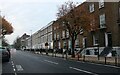
This page details the photographs taken nearby to Malden Crescent, NW1 8BS by members of the Geograph project.
The Geograph project started in 2005 with the aim of publishing, organising and preserving representative images for every square kilometre of Great Britain, Ireland and the Isle of Man.

There are currently over 7.5m images from over14,400 individuals and you can help contribute to the project by visiting https://www.geograph.org.uk
Image Map (Loading...)


Getting Data...Please wait
Leaflet Map data © OpenStreetMap
Images are licensed for reuse under creativecommons.org/licenses/by-sa/2.0
Notes
- Clicking on the map will re-center to the selected point.
- The higher the marker number, the further away the image location is from the centre of the postcode.
Image Listing (536 Images Found)
Images are licensed for reuse under creativecommons.org/licenses/by-sa/2.0
Image
Details
Distance
1
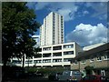
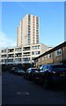
Hardington Estate
As seen from Belmont Road.
The large tower is called Vernon.
Image: © David Anstiss
Taken: 15 Aug 2017
0.03 miles
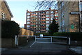
7
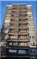
Hardington on Belmont Street, Chalk Farm
There are many of these similar council blocks across Camden which were built in the 60s. There are a good number in Swiss Cottage and Primrose Hill.
Image: © David Howard
Taken: 15 Jan 2023
0.06 miles
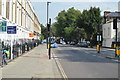
10

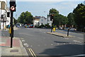
The Fiddler's Elbow, Prince of Wales Road / Malden Road, NW5
Image: © Mike Quinn
Taken: 10 Jun 2009
0.07 miles