IMAGES TAKEN NEAR TO
Regents Park Road, LONDON, NW1 8AT
Introduction
This page details the photographs taken nearby to Regents Park Road, NW1 8AT by members of the Geograph project.
The Geograph project started in 2005 with the aim of publishing, organising and preserving representative images for every square kilometre of Great Britain, Ireland and the Isle of Man.

There are currently over 7.5m images from over14,400 individuals and you can help contribute to the project by visiting https://www.geograph.org.uk
Image Map (Loading...)


Getting Data...Please wait
Leaflet Map data © OpenStreetMap
Images are licensed for reuse under creativecommons.org/licenses/by-sa/2.0
Notes
- Clicking on the map will re-center to the selected point.
- The higher the marker number, the further away the image location is from the centre of the postcode.
Image Listing (436 Images Found)
Images are licensed for reuse under creativecommons.org/licenses/by-sa/2.0
Image
Details
Distance
1
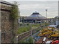
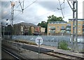
Primrose Hill railway station (site), Greater London
Opened in 1872 jointly by the North London Railway and London & North Western Railway, this was the third station near this site. It closed in 1992.
View east past the station building at the derelict former NLR platforms. The LNWR platforms would have been out of view to the right of the image, but have long since been removed. The first and second stations were both further away from the camera position.
Image: © Nigel Thompson
Taken: 14 Sep 2018
0.02 miles
2
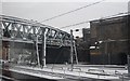
Footbridge over the West Coast Main Line, Camden
Image: © N Chadwick
Taken: 19 Dec 2010
0.02 miles
3
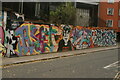
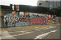
View of street art on Regent's Park Road #2
Looking northeast.
Image: © Robert Lamb
Taken: 24 Oct 2020
0.03 miles
5
View of street art on Regent's Park Road
Looking south-southwest.
Image: © Robert Lamb
Taken: 24 Oct 2020
0.04 miles
7
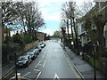
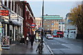
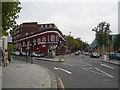
Adelaide Road, Chalk farm
Overlooking the station.
Image: © David Howard
Taken: 30 Oct 2008
0.04 miles
8
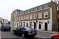
Commercial premises on Adelaide Road
Attractive building at the junction with Haverstock Hill, with curved attic windows mirroring the curved doors and windows on the ground floor.
Image: © Kate Jewell
Taken: 30 Mar 2014
0.04 miles
9
Primrose Hill railway station (site)
Opened in 1872 jointly by the North London Railway and the London & North Western Railway, this station closed in 1992.
View north from a passing train. The street level buildings and former NLR platforms were both extant when this image was taken. This was the third station near this site and it replaced an earlier 1855 station which would have been just out of view to the right. See also Image
For further information, see http://www.disused-stations.org.uk/p/primrose_hill/
Image: © Nigel Thompson
Taken: 3 Sep 2009
0.04 miles
10
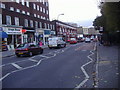
Chalk Farm Underground Station
Taken at the junction of Adelaide Road (branching to the left, towards Swiss Cottage) and Haverstock Hill (branching right, towards Hampstead).
Image: © Danny P Robinson
Taken: 28 Oct 2006
0.04 miles