IMAGES TAKEN NEAR TO
Park Road, LONDON, NW1 6XT
Introduction
This page details the photographs taken nearby to Park Road, NW1 6XT by members of the Geograph project.
The Geograph project started in 2005 with the aim of publishing, organising and preserving representative images for every square kilometre of Great Britain, Ireland and the Isle of Man.

There are currently over 7.5m images from over14,400 individuals and you can help contribute to the project by visiting https://www.geograph.org.uk
Image Map (Loading...)


Getting Data...Please wait
Leaflet Map data © OpenStreetMap
Images are licensed for reuse under creativecommons.org/licenses/by-sa/2.0
Notes
- Clicking on the map will re-center to the selected point.
- The higher the marker number, the further away the image location is from the centre of the postcode.
Image Listing (1084 Images Found)
Images are licensed for reuse under creativecommons.org/licenses/by-sa/2.0
Image
Details
Distance
2
Benchmark on gatepost of Francis Holland CE School, Park Road
Ordnance Survey cut mark benchmark described on the Bench Mark Database at http://www.bench-marks.org.uk/bm37532
Image: © Roger Templeman
Taken: 8 Apr 2011
0.02 miles
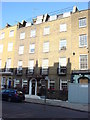
5

Francis Holland Church of England School
A grade II listed building, 1915.
Image: © Robin Webster
Taken: 28 Jan 2020
0.02 miles
6

Inscription above side door, Francis Holland Church of England School
Rather perplexing similes, To me, an interchange of roles would make slightly more sense - what regulates what?
Image: © Robin Webster
Taken: 28 Jan 2020
0.02 miles
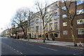
7
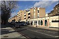
Northwest on Park Road, Marylebone, London
Viewed from the corner of Ivor Place Image
Image: © Robin Stott
Taken: 28 Jan 2020
0.02 miles
9
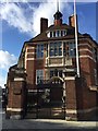
Front of Francis Holland Church of England School for Girls, Marylebone, London
Exuberantly, the architect H T Hare makes the most of a restricted space at the corner of Ivor Place and Park Road. Listed Grade II https://historicengland.org.uk/listing/the-list/list-entry/1226183 See also Image and Image
Image: © Robin Stott
Taken: 28 Jan 2020
0.02 miles
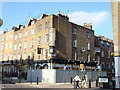
10
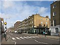
From a Pub to a School
On the corner here, and still looking pretty much like the pub it formerly was, is the Francis Holland School for girls.
It used to be the Gloucester Arms. This 2007 picture shows it during conversion. Image
Image: © Des Blenkinsopp
Taken: 3 Mar 2015
0.03 miles