IMAGES TAKEN NEAR TO
Dorset Square, LONDON, NW1 6QA
Introduction
This page details the photographs taken nearby to Dorset Square, NW1 6QA by members of the Geograph project.
The Geograph project started in 2005 with the aim of publishing, organising and preserving representative images for every square kilometre of Great Britain, Ireland and the Isle of Man.

There are currently over 7.5m images from over14,400 individuals and you can help contribute to the project by visiting https://www.geograph.org.uk
Image Map
Images are licensed for reuse under creativecommons.org/licenses/by-sa/2.0
Notes
- Clicking on the map will re-center to the selected point.
- The higher the marker number, the further away the image location is from the centre of the postcode.
Image Listing (1176 Images Found)
Images are licensed for reuse under creativecommons.org/licenses/by-sa/2.0
Image
Details
Distance
3
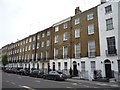
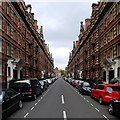
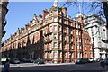
East side of Dorset Square, Gloucester Place, Marylebone, London
Gloucester Place runs parallel to Baker Street and many other streets.
Image: © Robin Stott
Taken: 28 Jan 2020
0.02 miles
4
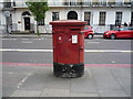
Double Elizabeth II postbox on Gloucester Place, London NW1
Postbox No. NW1 42.
See Image] for context.
Image: © JThomas
Taken: 15 Apr 2017
0.02 miles
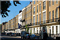
5
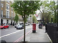
Gloucester Place, London NW1
Showing position of Postbox No. NW1 42.
See Image] for postbox.
Image: © JThomas
Taken: 15 Apr 2017
0.02 miles
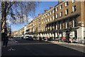
6
Glentworth Street, London
Architecture of Glentworth Street, Marylebone.
Image: © Oxfordian Kissuth
Taken: Unknown
0.02 miles
7
Benchmark on wall at south end of Chagford Street
Ordnance Survey cut mark benchmark described on the Bench Mark Database at http://www.bench-marks.org.uk/bm37526
Image: © Roger Templeman
Taken: 8 Apr 2011
0.02 miles
8
Clarence Gate Gardens at junction of Glentworth Street and Melcombe Street
Image: © Roger Templeman
Taken: 8 Apr 2011
0.02 miles
9
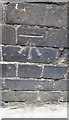
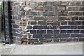
Ordnance Survey Cut Mark
This OS cut mark can be found on the east side of Chagford Street. It marks a point 27.164m above mean sea level.
Image: © Adrian Dust
Taken: 18 Aug 2016
0.02 miles